

- Usage in publication:
-
- Nanjemoy formation*
- Modifications:
-
- Named
- Dominant lithology:
-
- Sand
- AAPG geologic province:
-
- Atlantic Coast basin
Summary:
Named as top formation of Pamunkey group. Named for Nanjemoy Creek, Charles Co., southern MD. Subdivided into Woodstock member or substage above and Potapaco member or substage below. Consists generally of highly argillaceous greensand, as well as less frequent calcareous greensand. Some layers contain abundant crystals or crystalline masses of gypsum. Thickness is about 125 ft. Characterized by well-marked fauna representing clearly defined paleontologic stage. Unconformably underlies Chesapeake group; overlies Aquia formation of Pamunkey group. Age is Eocene.
Source: GNU records (USGS DDS-6; Reston GNULEX).
- Usage in publication:
-
- Nanjemoy formation*
- Modifications:
-
- Age modified
- AAPG geologic province:
-
- Atlantic Coast basin
Summary:
Correlation chart shows age as early and middle Eocene. Includes Potapaco clay member below and Woodstock greensand above. Overlies Aquia formation.
Source: GNU records (USGS DDS-6; Reston GNULEX).
- Usage in publication:
-
- Nanjemoy formation*
- Modifications:
-
- Revised
- AAPG geologic province:
-
- Atlantic Coast basin
Summary:
Marlboro clay member assigned to base of Nanjemoy formation.
Source: GNU records (USGS DDS-6; Reston GNULEX).
- Usage in publication:
-
- Nanjemoy formation*
- Modifications:
-
- Age modified
- AAPG geologic province:
-
- Atlantic Coast basin
Summary:
Nanjemoy formation with Marlboro clay member at base is part of Pamunkey group. For this paper Nanjemoy formation is just lower Eocene.
Source: GNU records (USGS DDS-6; Reston GNULEX).
- Usage in publication:
-
- Nanjemoy formation*
- Modifications:
-
- Overview
- AAPG geologic province:
-
- Atlantic Coast basin
Summary:
Lower Potapaco clay member of Nanjemoy is early Eocene; upper Woodstock greensand marl member is middle Eocene. Potapaco clay member truncates Aquia formation. Downdip, the Aquia formation and Potapaco member of Nanjemoy, as well as basal Marlboro clay member of Nanjemoy, have been truncated by transgressive sea of middle Eocene time during which upper part of Nanjemoy was deposited. Hence, eastward Woodstock member of Nanjemoy generally rests upon beds of Mattaponi formation (new) in subsurface. Underlies Chickahominy formation. Report includes subsurface data.
Source: GNU records (USGS DDS-6; Reston GNULEX).
- Usage in publication:
-
- Nanjemoy Formation*
- Modifications:
-
- Areal extent
- AAPG geologic province:
-
- Atlantic Coast basin
Summary:
Nanjemoy Formation geographically extended from the subsurface of eastern MD (Queen Annes Co.) to the subsurface of DE. Overlies Vincentown Formation of Rancocas Group; underlies Piney Point Formation. Nanjemoy not part of Pamunkey Group in DE.
Source: GNU records (USGS DDS-6; Reston GNULEX).
- Usage in publication:
-
- Nanjemoy Formation*
- Modifications:
-
- Age modified
- AAPG geologic province:
-
- Atlantic Coast basin
Summary:
Overall age of Nanjemoy Formation is early and middle Eocene. In report area, Nanjemoy and its two members (Potapaco (lower) and Woodstock (upper)) are early Eocene only.
Source: GNU records (USGS DDS-6; Reston GNULEX).

- Usage in publication:
-
- Nanjemoy Formation*
- Modifications:
-
- Revised
- AAPG geologic province:
-
- Atlantic Coast basin
Summary:
Marlboro Clay Member of Nanjemoy Formation of Pamunkey Group raised in rank to Marlboro Clay and reassigned to Pamunkey Group. Nanjemoy Formation now stratigraphically restricted to exclude Marlboro, formerly at its base. Pamunkey now includes (ascending): Brightseat Formation (not in this report area), Aquia Formation or Greensand, Marlboro Clay, and Nanjemoy Formation.
Source: GNU records (USGS DDS-6; Reston GNULEX).
- Usage in publication:
-
- Nanjemoy Formation*
- Modifications:
-
- Areal extent
- AAPG geologic province:
-
- Atlantic Coast basin
Summary:
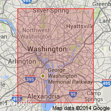
The Nanjemoy Formation is mapped in Washington, D.C. Described as chiefly drab clays and fine calcareous sands. Thickness ranges from a featheredge in the northwest to as much as 15 m in the southeast. Overlies Marlboro Clay. Shallow marine origin. Age is Eocene.
Source: GNU records (USGS DDS-6; Reston GNULEX).
- Usage in publication:
-
- Nanjemoy Formation*
- Modifications:
-
- Overview
- AAPG geologic province:
-
- Atlantic Coast basin
Summary:
Age of Nanjemoy in this report given as early and middle Eocene (51 to 45 m.y.). Unconformably underlies "Virginia St. Marys Formation" of Chesapeake Group and unconformably overlies Marlboro Clay in study area. [Report was reviewed by GNU in 1981, six years before publication, and may not reflect USGS usage in affect in 1987.]
Source: GNU records (USGS DDS-6; Reston GNULEX).
- Usage in publication:
-
- Nanjemoy Formation
- Modifications:
-
- Overview
- AAPG geologic province:
-
- Atlantic Coast basin
Summary:
Nanjemoy Formation in Charles Co. is dark grayish green to olive black fine- to medium-grained glauconitic quartz sand and dark greenish gray silty clay. Locally sand is either very muddy or contains many small quartz pebbles, and the clay is silty or sandy. Unit is fossiliferous with abundant VENERICARDIA. Crops out in valleys in western half of county. Maximum thickness 230 ft in eastern part of county. Underlies Calvert Formation or younger units; overlies Marlboro Clay. Both unconformable contacts are burrowed and marked by abrupt lithological change. Nanjemoy cannot be divided into members throughout Charles Co. Deposited on shallow shelf. Age is early Eocene. [Nomenclature used in this report reflects that of the Maryland Geological Survey.]
Source: GNU records (USGS DDS-6; Reston GNULEX).
- Usage in publication:
-
- Nanjemoy Formation
- Modifications:
-
- Biostratigraphic dating
- AAPG geologic province:
-
- Atlantic Coast basin
Summary:
Woodstock Member of the Nanjemoy Formation at Popes Creek, Charles Co., MD, contains a well preserved dinoflagellate cyst assemblage containing approximately 115 species. Analysis suggests that the Woodstock belongs to NP12 and to an unknown part of NP13, while the Potapaco Member belongs to NP11, according to studies by Costa and Downie (1976). The Nanjemoy, therefore, is early to late Ypresian.
Source: GNU records (USGS DDS-6; Reston GNULEX).

- Usage in publication:
-
- Nanjemoy Formation
- Modifications:
-
- Overview
- AAPG geologic province:
-
- Atlantic Coast basin
Summary:
Undifferentiated Pamunkey Group, Old Church Formation, and unnamed late Oligocene glauconitic sands are lumped on the State map as lower Tertiary deposits. Individual units are discussed in the text. Nanjemoy Formation is described as dark-olive-gray, greenish-gray, and olive-black glauconitic quartz sand, fine- to coarse-grained, very clayey and silty, intensely burrowed, sparsely to abundantly shelly, interbedded with sandy clay-silt. Sand in upper part of unit is less clayey, very micaceous, and contains scattered quartz pebbles. Typical mollusks include VENERICARDIA POTAPACOENSIS, VENERICARDIA ASCIA, AND MACROCALLISTA SUBIMPRESSA. Unit ranges in thickness from 0 to 140 ft. Age is early Eocene.
Source: GNU records (USGS DDS-6; Reston GNULEX).
- Usage in publication:
-
- Nanjemoy Formation*
- Modifications:
-
- Biostratigraphic dating
- AAPG geologic province:
-
- Atlantic Coast basin
Summary:
The Nanjemoy Formation in VA and MD is included in calcareous nannofossil zones NP10 through NP13 and is of early Eocene age. The Nanjemoy unconformably overlies the Marlboro Clay of late Paleocene age. The Paleocene-Eocene boundary (Zones NP9-NP10 boundary) occurs within the hiatus between these two formations. The Nanjemoy Formation consists of poorly sorted, very fine to fine-grained glauconitic quartz sand that contains varying amounts of clay.
Source: GNU records (USGS DDS-6; Reston GNULEX).
For more information, please contact Nancy Stamm, Geologic Names Committee Secretary.
Asterisk (*) indicates published by U.S. Geological Survey authors.
"No current usage" (†) implies that a name has been abandoned or has fallen into disuse. Former usage and, if known, replacement name given in parentheses ( ).
Slash (/) indicates name conflicts with nomenclatural guidelines (CSN, 1933; ACSN, 1961, 1970; NACSN, 1983, 2005, 2021). May be explained within brackets ([ ]).