The National Geologic Map Database is migrating to a new infrastructure. We apologize for any service disruptions during this process.
|
|---|


- Usage in publication:
-
- Naknek Lake Granite
- Modifications:
-
- Named
- AAPG geologic province:
-
- Bristol Bay basin[?]
- Alaska Peninsula province
- Alaska Southwestern region
Summary:
Pt. 1, p. 38, 39, 48. Naknek Lake Granite. Term used in discussion of Naknek Formation. Spurr (1900) considered Naknek Formation to have been derived from early Jurassic hornblende-biotite Naknek Lake Granite exposed along axis of Aleutian Range northeast of Becharof Lake. [Compiler unable to locate statement in which Spurr used formal expression "Naknek Lake Granite. "] Age is Early Jurassic.
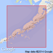
Naknek Lake batholith is on Alaska Peninsula, southwestern AK.
Source: US geologic names lexicon (USGS Bull. 1350, p. 518).
For more information, please contact Nancy Stamm, Geologic Names Committee Secretary.
Asterisk (*) indicates published by U.S. Geological Survey authors.
"No current usage" (†) implies that a name has been abandoned or has fallen into disuse. Former usage and, if known, replacement name given in parentheses ( ).
Slash (/) indicates name conflicts with nomenclatural guidelines (CSN, 1933; ACSN, 1961, 1970; NACSN, 1983, 2005, 2021). May be explained within brackets ([ ]).