

- Usage in publication:
-
- Naches formation*
- Modifications:
-
- Named
- Biostratigraphic dating
- Dominant lithology:
-
- Sandstone
- Basalt
- AAPG geologic province:
-
- Cascades province
Summary:
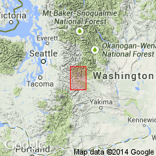
Named for Naches River where unit is well exposed along northeast side of valley in southern Kittitas Co, WA. [no type locality designated]. Principal exposures are along northeast side of Naches valley and extend northward to Yakima River valley. Is entirely within Snoqualmie quad. Consists of interbedded sedimentary and volcanic rocks; sedimentary rocks dominate in lower part, volcanic rocks (mainly basalt) in upper part. Sedimentary part of unit is similar to and probably contemporary with Swauk formation. Is about 4000 ft thick [in central part]. Unconformably overlies pre-Tertiary metamorphic rocks. Overlain unconformably by Keechelus volcanics. Age assigned is Eocene based on similarity of plant fossils to those of Swauk formation.
Source: GNU records (USGS DDS-6; Menlo GNULEX).
- Usage in publication:
-
- Naches formation*
- Modifications:
-
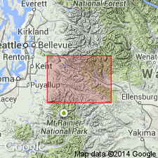
- Areal extent
- Overview
- AAPG geologic province:
-
- Cascades province
Summary:
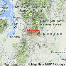
Naches formation is extended northwestward several mi to Lundin Peak in King Co, 3 mi north of Snoqualmie Pass. Is apparently unconformably overlain there by Keechelus andesite, and underlain concordantly by Mount Catherine rhyolite. Is locally intruded by Snoqualmie granodiorite. Is 5000 ft thick, as extended, consisting of basalt, sedimentary rocks and rhyolite with marked variation in relative proportions from place to place, although basalt is more prevalent in lower part. Age previously considered same as that of Swauk formation because similar fossil leaves found in both Naches and Swauk. Evidence suggests both units are fluviatile, and despite fossil leaves, complete lack of contemporaneous volcanic rocks in Swauk suggests units are of different ages. Age "may be Eocene".
Source: GNU records (USGS DDS-6; Menlo GNULEX).
- Usage in publication:
-
- Naches Formation*
- Modifications:
-
- Age modified
- Biostratigraphic dating
- Geochronologic dating
- AAPG geologic province:
-
- Cascades province
Summary:
Naches Formation unconformably overlies pre-Tertiary metamorphic rocks and is unconformably overlain by less intensely deformed late Oligocene and Miocene pyroclastic rocks that are probably correlative with Ohanapecosh or Stevens Ridge Formations. Is divisible into [at least] three lithological units that are (descending): (A) interbedded basalt, basaltic tuff and breccia, and arkosic sandstone with minor rhyolite tuff and flows, and andesite flows(?); lower part is thick rhyolite flows and ash-flow tuff; (fission-track ages range from 39 to 34 Ma); (B) columnar-jointed basalt and basalt breccia; on east, unit contains andesite flows and breccia; (fission-track age on rhyolite near base is 45 +/-5 Ma); (C) arkosic sandstone with minor shale, conglomerate, and coal beds; (flora is unlike Eocene part of Swauk or Roslyn Formations but correlative with Clarno Formation of Eocene and Oligocene age). Age of Naches Formation is considered late Eocene and Oligocene(?).
Source: GNU records (USGS DDS-6; Menlo GNULEX).
- Usage in publication:
-
- Naches Formation*
- Modifications:
-
- Revised
- Geochronologic dating
- AAPG geologic province:
-
- Cascades province
Summary:
Guye Formation (Smith and Calkins, 1906; Foster, 1960) reduced to Guye Sedimentary Member of Naches Formation --[in basal part]. Mount Catherine Rhyolite (Foster, 1960) reduced to Mount Catherine Rhyolite Member of Naches Formation --[Mount Catherine intertongues with and overlies Guye Sedimentary Member]. In northernmost outcrops near Cascades crest, north of Snoqualmie Pass, Naches Formation is unconformably overlain by andesitic breccia and tuff of probable Oligocene age, In that area, unit is between 1500 and 3000 m thick. Is younger than Swauk Formation on basis of leaf fossils and stratigraphic arguments. Isotopic data from lower part of unit indicate age of about 44 to 40 Ma (middle to late Eocene). Age of Naches Formation is Eocene and Oligocene(?).
Source: GNU records (USGS DDS-6; Menlo GNULEX).
- Usage in publication:
-
- Naches Formation*
- Modifications:
-
- Age modified
- Areal extent
- AAPG geologic province:
-
- Cascades province
Summary:
Naches Formation is geographically extended into report area. Age is revised [everywhere] from late Eocene and Oligocene(?) to: middle Eocene to early Oligocene(?) based on radiometric data (K-Ar) and regional stratigraphic relations.
Source: GNU records (USGS DDS-6; Menlo GNULEX).
For more information, please contact Nancy Stamm, Geologic Names Committee Secretary.
Asterisk (*) indicates published by U.S. Geological Survey authors.
"No current usage" (†) implies that a name has been abandoned or has fallen into disuse. Former usage and, if known, replacement name given in parentheses ( ).
Slash (/) indicates name conflicts with nomenclatural guidelines (CSN, 1933; ACSN, 1961, 1970; NACSN, 1983, 2005, 2021). May be explained within brackets ([ ]).