

- Usage in publication:
-
- Murphy marble*
- Modifications:
-
- Named
- Dominant lithology:
-
- Marble
- AAPG geologic province:
-
- Piedmont-Blue Ridge province
Summary:
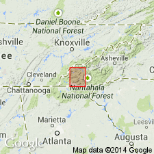
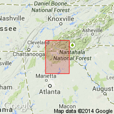
Murphy marble (new name) mapped in the Nantahala quad, NC and SC, is composed entirely of marble, rather fine-grained and wholly recrystallized from original condition. Predominant color is white, but a large portion is dark gray or blue, and many layers consist of banded or mottled blue and white. Some layers between Nantahala and Red Marble Gap have a beautiful rose-pink color. Base is exposed near Nantahala River, where it passes downward into Valleytown formation by interbedding with the slates of the latter. Upward it passes into Andrews schist through several ft of interbedded marble and schist. Thickness 150 to 500 ft.
Source: GNU records (USGS DDS-6; Reston GNULEX).
- Usage in publication:
-
- Murphy marble*
- Modifications:
-
- Areal extent
- Overview
- AAPG geologic province:
-
- Piedmont-Blue Ridge province
Summary:
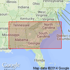
Murphy marble is present only in the Murphy syncline. Nottely quartzite is in contact with the marble only in main belt from Ellijay, GA, northeastward. Murphy syncline is a tightly compressed compound syncline and at most places is bounded by thrust faults. These faults cut off Murphy marble at northeast and at many places cut out both the marble and Nottely quartzite. In places in northeastern part of syncline, Valleytown formation is on both sides of the marble apparently in fault contact. Elsewhere the marble, and in places the Nottely, are in fault contact with the Nantahala slate and Great Smoky quartzite. It is generally agreed that sequence (ascending) is Valleytown formation, Murphy marble, Andrews schist, and Nottely quartzite. Only locality where Valleytown was found to be in normal contact with overlying formations is in main syncline in northern GA where the Nottely dips 70 degrees southeast to vertical and lies between the marble at the west and the Valleytown at the east. A coarse conglomerate on the east side of the quartzite is in contact the Valleytown. The conglomerate suggests a coarse initial sediment at base of clastic deposits. If conglomerate is at base of the Nottely, that quartzite is overturned and overlies the Valleytown and underlies the Murphy marble at west, and the stratigraphic order of conglomerate, quartzite, and limestone is the common order of sedimentary deposition. It is suggested that Murphy marble may represent the Lower Cambrian dolomite horizon, and Nottely quartzite the underlying Lower Cambrian quartzite and that the Andrews schist represents the iron- and manganese-bearing transition zone commonly present at the top of Lower Cambrian formations and therefore overlies the Valleytown. [Valleytown and Brasstown here are treated as one unit--the Valleytown.]
Source: GNU records (USGS DDS-6; Reston GNULEX).
- Usage in publication:
-
- Murphy Group
- Murphy Marble
- Modifications:
-
- Revised
- AAPG geologic province:
-
- Piedmont-Blue Ridge province
Summary:
Because of a regional unconformity below the Mineral Bluff Formation, it is removed from the Murphy Group in accordance with the Stratigraphic Code. As mapped here, the Murphy Group consists of two major sequences: lower clastic sequence includes the Nantahala and Brasstown Formations, locally separated by the Tusquitee Quartzite and the upper carbonate sequence includes the Murphy Marble, the Andrews Schist, and the Marble Hill Hornblende Schist.
Source: GNU records (USGS DDS-6; Reston GNULEX).
- Usage in publication:
-
- Murphy Marble
- Modifications:
-
- Overview
- AAPG geologic province:
-
- Piedmont-Blue Ridge province
Summary:
Keith's (1907) original use of term Murphy Marble takes precedence over the use of any group level term containing the word Murphy, such as Murphy group (Hatcher, 1972), Murphy series (Furcron, 1953), Murphy sequence (Forrest, 1969), Murphy belt group (Mohr, 1973), and Murphy syncline group (Nesbitt and Essene, 1982), all of which are here abandoned. The term Murphy belt is used to designate the longitudinal area of the western Blue Ridge stretching 175 km from Almond, NC, to Canton, GA, and underlain by stratigraphic units previously referred to as Murphy group. Those units are here renamed Hiwassee River (new) and Mineral Bluff (revised) Groups. Murphy Marble is the most distinctive and economically important unit in the Murphy belt and is here assigned to the top of the Hiwassee River Group. Underlies Marble Hill Hornblende Schist of the Mineral Bluff Group and overlies Brasstown Formation, also of Hiwassee River Group.
Source: GNU records (USGS DDS-6; Reston GNULEX).
For more information, please contact Nancy Stamm, Geologic Names Committee Secretary.
Asterisk (*) indicates published by U.S. Geological Survey authors.
"No current usage" (†) implies that a name has been abandoned or has fallen into disuse. Former usage and, if known, replacement name given in parentheses ( ).
Slash (/) indicates name conflicts with nomenclatural guidelines (CSN, 1933; ACSN, 1961, 1970; NACSN, 1983, 2005, 2021). May be explained within brackets ([ ]).