

- Usage in publication:
-
- Mulatto tongue*
- Modifications:
-
- Original reference
- AAPG geologic province:
-
- San Juan basin
Summary:
Mulatto tongue of Mancos shale. The lower tongue of Mancos shale (marine) that grades laterally into Mesaverde formation (nonmarine) of part of area from Gallup eastward toward Mount Taylor, New Mexico, is named by C.B. Hunt (USGS Bull. 860-B, 1934 [1936]) Mulatto tongue of Mancos shale, from its excellent exposures at mouth of Canyon Mulatto, in T. 14 N., R. 9 W. It in part underlies and in part grades laterally into Dalton sandstone member of Mesaverde formation, both of which are Colorado age [Late Cretaceous].
Source: US geologic names lexicons (USGS Bull. 896, p. 1449-1450).
- Usage in publication:
-
- Mulatto tongue*
- Modifications:
-
- Principal reference
- Dominant lithology:
-
- Shale
- Sandstone
- AAPG geologic province:
-
- San Juan basin
Summary:
Pg. 44-45, pls. Mulatto tongue of Mancos shale. Lies between Dilco coal member and Dalton sandstone member of Mesaverde formation. Toward southern part of Mount Taylor coal field the tongue is largely light-tan marine sandy shale with some thin sandstones and very local grits. Northward the proportion of shale increases until, where Gullup and Dilco members of the Mesaverde thin out, the Mulatto tongue is entirely dark-gray shale and cannot be distinguished lithologically from main body of Mancos and is there mapped with rest of Mancos. Thickness of Mulatto tongue ranges from 250 feet (in southern part of Mount Taylor field) to 400 feet (in northern part of field). [Age is Late Cretaceous.]
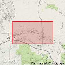
Name is here given for exposures at south end of Canyon Mulatto, 9 mi northwest of town of San Mateo, [near bdry. btw. secs. 22 and 23 (unsurveyed), T. 14 N., R.9 W., Ambrosia Lake 7.5-min quadrangle (1981 ed.), MicKinley Co., southwestern corner Cibolo National Forest], Gallup region, northwestern NM. Best exposures are in southward-facing scarp [of San Mateo Mesa, northwest of San Mateo in T. 14 and 15 N., R. 8 and 9 W., San Lucas Dam and Ambrosia Lake 7.5-min quadrangles, McKinley Co., northwestern NM].
Source: US geologic names lexicons (USGS Bull. 896, p. 1449-1450; USGS Bull. 1200, p. 2653).
- Usage in publication:
-
- Mulatto Tongue*
- Modifications:
-
- Mapped 1:500k
- Biostratigraphic dating
- Dominant lithology:
-
- Shale
- Sandstone
- AAPG geologic province:
-
- San Juan basin
Summary:
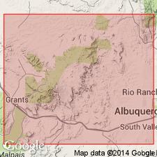
Pg. E6 (fig. 3), E14-E15 (fig. 7), E23, E34 (fig. 16), geol. map. Mulatto Tongue of Mancos Shale. Dark-gray sandy marine shale and numerous thin beds of fine-grained calcareous sandstone. Becomes more sandy southward toward its pinchout. Maximum thickness in Mesa de los Lobos area about 220 feet (Sears and others, 1941); according to D.L. Zieglar (written commun., 1953), is about 525 feet thick in Toadlena area, Chuska Mountains, Navajo Indian Reservation, San Juan County, northwestern New Mexico. [Mapped in San Juan and McKinley Counties, northwestern New Mexico; from Todilto Park southward to Crevasse Canyon, Chuska Mountains, Navajo Indian Reservation, and to southeast in Mesa de los Lobos area.] Fossil collection from Mulatto in Tohachi area, McKinley County, yielded Western Interior zonal index ammonoid INOCERAMUS DEFORMIS (Cobban and Reeside, 1952) indicating the Mulatto is correlative with the basal Niobrara Formation. Age is Late Cretaceous.
Source: Publication.
For more information, please contact Nancy Stamm, Geologic Names Committee Secretary.
Asterisk (*) indicates published by U.S. Geological Survey authors.
"No current usage" (†) implies that a name has been abandoned or has fallen into disuse. Former usage and, if known, replacement name given in parentheses ( ).
Slash (/) indicates name conflicts with nomenclatural guidelines (CSN, 1933; ACSN, 1961, 1970; NACSN, 1983, 2005, 2021). May be explained within brackets ([ ]).