

- Usage in publication:
-
- Mt. Zion Formation
- Modifications:
-
- Named
- Dominant lithology:
-
- Phyllite
- AAPG geologic province:
-
- Piedmont-Blue Ridge province
Summary:
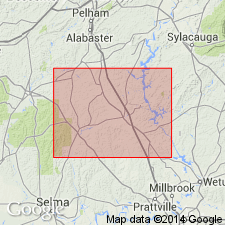
Name Mt. Zion Formation introduced in this report for black and cream phyllite exposed near Mt. Zion Church, Chilton Co., central AL. Phyllite is locally laminated, silvery-gray when weathered. Thickness ranges from 90 to 150 m. Neither upper nor lower contacts are exposed, but apparently unit underlies Jumbo Dolomite. Age is Early Devonian.
Source: GNU records (USGS DDS-6; Reston GNULEX).
- Usage in publication:
-
- Mt. Zion Formation
- Modifications:
-
- Not used
- AAPG geologic province:
-
- Piedmont-Blue Ridge province
Summary:
Strata referred to by Carrington (1973) as Kalona quartzite and Mt. Zion Formation are included in Wash Creek Formation of Kahatchee Mountain Group in this area.
Source: GNU records (USGS DDS-6; Reston GNULEX).
For more information, please contact Nancy Stamm, Geologic Names Committee Secretary.
Asterisk (*) indicates published by U.S. Geological Survey authors.
"No current usage" (†) implies that a name has been abandoned or has fallen into disuse. Former usage and, if known, replacement name given in parentheses ( ).
Slash (/) indicates name conflicts with nomenclatural guidelines (CSN, 1933; ACSN, 1961, 1970; NACSN, 1983, 2005, 2021). May be explained within brackets ([ ]).