

- Usage in publication:
-
- Mount Pablo Formation*
- Modifications:
-
- Original reference
- Dominant lithology:
-
- Sandstone
- Mudstone
- Limestone
- AAPG geologic province:
-
- Sweetgrass arch
- North Western Overthrust
Summary:
Strata of the Mount Pablo Formation, here named, were formerly assigned to the lower part of the Kootenai Formation, now geographically and stratigraphically restricted; the unnamed formation of Mudge, Earhart, and Rice (1977), Mudge, Earhart, and Claypool (1977), Mudge and Earhart (1979), and Mudge (1979); and the western facies of the Morrison Formation by Mudge (1972). Includes at its base the Cut Bank Sandstone Member, here geographically extended to the Sawtooth Range from the Cut Bank area where it is a member of the Kootenai Formation. Consists of gray, poorly sorted, cross-bedded, coarse- to very fine-grained sandstone and conglomerate in the lower part, variegated gray and greenish-gray mudstone interbedded with some sandstone in the middle part, and distinctive light-gray limestone interbedded with and overlain by gray-brown mudstone in the upper part. Unconformably overlies the Morrison Formation in most places; at the type section the Cut Bank Sandstone Member unconformably overlies the Swift Formation; unconformably underlies the Kootenai Formation. Correlates with the lower part of the Kootenai in the Cut Bank area. Thickness at the type section is 61 m and ranges from 34 m to 90 m. The Mount Pablo is the lowest Cretaceous unit in the Sawtooth Range. Age is Early Cretaceous (possibly late Aptian and early Albian) based on fossils (palynomorphs).
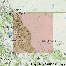
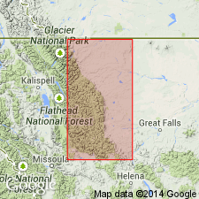
Type section: exposure on north side of Badger Creek in the Blackfeet Indian Reservation, in NE/4 SW/4 sec. 3, T. 29 N., R. 11 W., Half Dome Crag quadrangle, Pondera Co., northwestern MT. Named from Mount Pablo in the Sawtooth Range, 14 km south of East Glacier Park, Glacier Co., northwestern MT.
Source: US geologic names lexicon (USGS Bull. 1565, p. 210).
- Usage in publication:
-
- Mount Pablo Formation*
- Modifications:
-
- Mapped
- Dominant lithology:
-
- Sandstone
- Mudstone
- Limestone
- AAPG geologic province:
-
- Sweetgrass arch
- North Western Overthrust
Summary:
Mount Pablo Formation. Nonmarine, formerly referred to as western facies of Morrison Formation in Sun River Canyon area (Mudge, 1972). Consists of limestone, mudstone, and sandstone in upper part, variegated mudstone interbedded with sandstone in middle part, and sandstone and conglomerate in lower part (Cut Bank Sandstone Member). Thickness 0 to about 90 m. Unconformably underlies Kootenai Formation. Unconformably overlies Morrison Formation except in northeastern outcrops where it overlies Swift Formation. Age is Early Cretaceous.
Flathead, Pondera
Source: Publication.
For more information, please contact Nancy Stamm, Geologic Names Committee Secretary.
Asterisk (*) indicates published by U.S. Geological Survey authors.
"No current usage" (†) implies that a name has been abandoned or has fallen into disuse. Former usage and, if known, replacement name given in parentheses ( ).
Slash (/) indicates name conflicts with nomenclatural guidelines (CSN, 1933; ACSN, 1961, 1970; NACSN, 1983, 2005, 2021). May be explained within brackets ([ ]).