The National Geologic Map Database is migrating to a new infrastructure. We apologize for any service disruptions during this process.
|
|---|


- Usage in publication:
-
- Mount Baldy Formation
- Modifications:
-
- Named
- Dominant lithology:
-
- Latite
- Quartz latite
- Trachyte
- Tuff
- AAPG geologic province:
-
- Black Mesa basin
Summary:
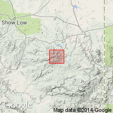
Named for highest peak of the White Mountains, located in southern Apache Co, AZ, Black Mesa basin. Type locality is along ridge between East Fork of Little Colorado River and West Fork of Black River. Outcrops in central part of mapped area. Divided into lower and upper members. Lower member has less volume than upper and is composed primarily of latite. Upper member has a higher percentage of quartz latite flows intercalated with alkali trachyte, latite and quartz latite. Locally occurring at base of upper member is a partially welded alkali trachyte tuff, 3-4 m thick. Formation was erupted from Mount Baldy onto a landscape having as much as 600 m of relief. Extensive erosion of lavas has made it difficult to correlate them over large distances. Lower member may have reached a total thickness of 200 m with individual flows averaging 20-30 m; upper member has a thickness of about 400 m with individual flows averaging 20-40 m. Total thickness of formation now present is less than 500 m. Detailed petrologic description and chemistry; cross sections. Overlies early volcanic and volcaniclastic rocks (deposited between 38-12 m.y. ago); underlies and in part coeval with Sheep Crossing Formation (revised). Mount Baldy lavas believed to have erupted between 12-8 m.y. ago (late Miocene) based on estimated age of underlying volcanic and volcaniclastic rocks and K-Ar ages of 8.6 and 8.9 m.y. on rhyolite and basalt overlying Sheep Crossing.
Source: GNU records (USGS DDS-6; Denver GNULEX).
For more information, please contact Nancy Stamm, Geologic Names Committee Secretary.
Asterisk (*) indicates published by U.S. Geological Survey authors.
"No current usage" (†) implies that a name has been abandoned or has fallen into disuse. Former usage and, if known, replacement name given in parentheses ( ).
Slash (/) indicates name conflicts with nomenclatural guidelines (CSN, 1933; ACSN, 1961, 1970; NACSN, 1983, 2005, 2021). May be explained within brackets ([ ]).