

- Usage in publication:
-
- Mount Baldy Rhyolite Member*
- Modifications:
-
- Named
- AAPG geologic province:
-
- Great Basin province
Summary:
Unit is named the Mount Baldy Rhyolite Member of the Mount Belknap Volcanics. Consists of fine-grained, light-gray to white rhyolite. Flows are contorted and locally prominent. Overlies the Blue Lake Rhyolite Member or unnamed middle tuff or sedimentary breccia members; units are part of the intracaldera facies of the Mount Belknap Volcanics. Age is Miocene [19 Ma]. (B1564)
Source: GNU records (USGS DDS-6; Menlo GNULEX).
- Usage in publication:
-
- Mount Baldy Rhyolite Member*
- Modifications:
-
- Named
- Dominant lithology:
-
- Rhyolite
- AAPG geologic province:
-
- Great Basin province
Summary:
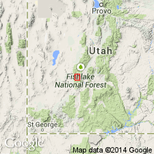
Named as part of the intracaldera facies of and as a member of Mount Belknap Volcanics for exposures on precipitous cliffs forming the upper slopes of Mount Baldy (the type area), Beaver Co, UT in the Great Basin province. Is composed of crystal poor rhyolite lava flows that consist of a granular mosaic of quartz, alkali feldspar, minor plagioclase, biotite, and hematite. Some of the flows are as much as 500-700 m thick and 1-2 km across; is 300 m thick at type. Is younger than the middle tuff member. Is associated with sedimentary breccia member. Was derived from the Mount Belknap caldera. Assigned to the Miocene.
Source: GNU records (USGS DDS-6; Denver GNULEX).
For more information, please contact Nancy Stamm, Geologic Names Committee Secretary.
Asterisk (*) indicates published by U.S. Geological Survey authors.
"No current usage" (†) implies that a name has been abandoned or has fallen into disuse. Former usage and, if known, replacement name given in parentheses ( ).
Slash (/) indicates name conflicts with nomenclatural guidelines (CSN, 1933; ACSN, 1961, 1970; NACSN, 1983, 2005, 2021). May be explained within brackets ([ ]).