The National Geologic Map Database is migrating to a new infrastructure. We apologize for any service disruptions during this process.
|
|---|


- Usage in publication:
-
- Mossman picritic basalt*
- Modifications:
-
- Named
- Dominant lithology:
-
- Basalt
- AAPG geologic province:
-
- Maui
Summary:
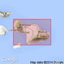
Named for Mossman's Spring which issues from it. Known by local workers as "Tame Turkey lava". Forms surface area between Hanawi and Makapipi Streams and along east coast of Nahika, east Maui. Included as unit of Hana volcanic series. Is single wide spread flow of pahoehoe composed of thin flow units of moderately vesicular picritic basalt. Maximum thickness of 80 ft in drillholes but averages 35 ft. Along hwy overlies Makaino basaltic andesite (new) east of Makapipi Stream; unconformably underlies Kuhiwa basaltic andesite (new) (both units of Hana volcanic series). In drillholes 48, 49, and 56 is underlain by olivine basalt not recognized elsewhere. In many places overlies several inches of baked soil. At west distributary of Makaino Stream overlies conglomerate of subrounded pebbles in yellowish-brown clay matrix. Map shows middle(?) and late Pleistocene and Recent age.
Source: GNU records (USGS DDS-6; Menlo GNULEX).
- Usage in publication:
-
- Mossman picritic basalt*
- Modifications:
-
- Age modified
- AAPG geologic province:
-
- Maui
Summary:
Type locality: Mossman Spring [20 deg 49' 00"N, 156 deg 06' 00"W, Nahiku area, eastern Maui]. [Mossman Spring not on topo map]. Assigned Pleistocene(?) age. [no basis given]
Source: GNU records (USGS DDS-6; Menlo GNULEX).

- Usage in publication:
-
- Mossman Picritic Basalt†
- Modifications:
-
- Abandoned
- AAPG geologic province:
-
- Maui
Summary:
Mossman Picritic Basalt of Stearns and Macdonald (1942) abandoned as formally named unit and called Mossman flow of Hana Volcanics. Hana Volcanics assigned Pleistocene(?) and Holocene age.
Source: GNU records (USGS DDS-6; Menlo GNULEX).
For more information, please contact Nancy Stamm, Geologic Names Committee Secretary.
Asterisk (*) indicates published by U.S. Geological Survey authors.
"No current usage" (†) implies that a name has been abandoned or has fallen into disuse. Former usage and, if known, replacement name given in parentheses ( ).
Slash (/) indicates name conflicts with nomenclatural guidelines (CSN, 1933; ACSN, 1961, 1970; NACSN, 1983, 2005, 2021). May be explained within brackets ([ ]).