

- Usage in publication:
-
- Moreno Grande formation
- Modifications:
-
- [First used]
- AAPG geologic province:
-
- Sacramento basin
Summary:
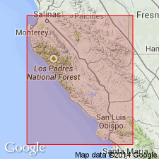
Pg. 472. Moreno Grande formation. Name proposed for original Moreno [of Anderson and Pack (1915)] and part of underlying Panoche formation. Name credited to A.S. Huey (unpub. manuscript).
Source: US geologic names lexicon (USGS Bull. 1200, p. 2589-2590).
- Usage in publication:
-
- Moreno Grande formation
- Modifications:
-
- [Original reference]
- Dominant lithology:
-
- Shale
- Sandstone
- AAPG geologic province:
-
- Sacramento basin
Summary:
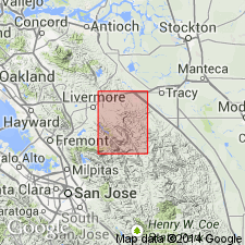
Pg. 16 (fig. 2), 31-33, pls. 1, 2, 3. Moreno Grande formation. Described as consisting of siliceous, argillaceous, and sandy shale, sandstone beds, limestone concretions, and locally, buff sandstone at top. Thickness as much as 650 feet. As defined, the Moreno Grande, north of Pacheco Pass, comprises the Moreno as mapped by Anderson and Pack (1915); southward to Coalinga region, the formation comprises the restricted Moreno, Brown Mountain sandstone, and the Ragged Valley (PACHYDISCUS silt) as members. Unconformably underlies Tesla formation; overlapped by Cierbo formation on the north; contact with underlying Panoche not well exposed but appears to be conformable and gradational. Along southside of Corral Hollow, the Moreno Grande dips steeply northward at angles of 60 to 80 deg. into a syncline. Age is Late Cretaceous.
Type locality not stated. Occurs in Tesla quadrangle which comprises about 240 sq. mi. in parts of Alameda and San Joaquin Cos., west-central CA.
Source: US geologic names lexicon (USGS Bull. 1200, p. 2589-2590).
For more information, please contact Nancy Stamm, Geologic Names Committee Secretary.
Asterisk (*) indicates published by U.S. Geological Survey authors.
"No current usage" (†) implies that a name has been abandoned or has fallen into disuse. Former usage and, if known, replacement name given in parentheses ( ).
Slash (/) indicates name conflicts with nomenclatural guidelines (CSN, 1933; ACSN, 1961, 1970; NACSN, 1983, 2005, 2021). May be explained within brackets ([ ]).