

- Usage in publication:
-
- Montoya limestone*
- Modifications:
-
- First used
- Dominant lithology:
-
- Limestone
- Chert
- AAPG geologic province:
-
- Orogrande basin
- Permian basin
Summary:
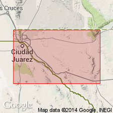
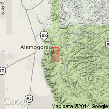
First use of name; intent to name not stated; no type locality designated; origin of name not discussed. Present in El Paso quad, El Paso Co, TX in Orogrande basin, and Van Horn quad, Culberson Co, TX in Permian basin. Is a limestone recognized by stratigraphic position and fossils in both quads. Overlain by Fusselman limestone (new) of Silurian age in El Paso quad; overlain by Pennsylvanian Hueco limestone in Van Horn quad. Younger than Ordovician El Paso limestone. Contains 2 distinct faunas, the Richmond and Galena; thickness is about 250 ft. Galena fossils occur in lower part, zone being commonly marked in El Paso quad by massive dark-colored limestone containing little or no chert. Upper part of limestone is mostly gray, with some nearly white and some dark beds; the 2 parts of Montoya cannot always be distinguished lithologically. Zone which carries most abundant Richmond fossils in places is seamed with conspicuous bands of chert a few in thick. In Van Horn quad, base commonly marked by thin-bedded earthy yellow and reddish limestone, but otherwise in both quads contact is apparently conformable. Like El Paso limestone, Montoya is characteristically magnesian. Galena and Richmond fauna of trans-Pecos TX are similar to those of the Mississippi Valley, OK, the Black Hills, Big Horn Mountains, and elsewhere. Fossil lists. Middle and Late Ordovician.
Source: GNU records (USGS DDS-6; Denver GNULEX).
- Usage in publication:
-
- Montoya limestone*
- Modifications:
-
- Revised
- AAPG geologic province:
-
- Basin-and-Range province
Summary:
Montoya limestone is revised in that it now unconformably underlies the newly named Gym limestone (of Late Pennsylvanian age) in Florida Mountains, Luna Co, NM in Basin-and-Range province, and also underlies newly named Lobo formation in parts of northern Florida Mountains. In Victorio Mountains, Montoya underlies or is faulted against Gym limestone. Geologic map. Montoya is of Late Ordovician age.
Source: GNU records (USGS DDS-6; Denver GNULEX).
- Usage in publication:
-
- Montoya limestone*
- Modifications:
-
- Overview
- Areal extent
- AAPG geologic province:
-
- Basin-and-Range province
Summary:
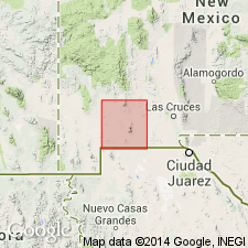
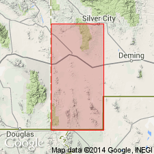
Montoya limestone present in Silver City quad, Grant Co, NM in Basin-and-Range province. Largely confined to eastern slope of mountain ranges that are made up of sedimentary rock. Descends in a broad sheet from the summit of Lone Mountain to its eastern base, where it dips beneath the Devonian shale. In Silver City Range, at Treasure Mountain, and in the hills on the northwest it occupies a similar characteristic position. Near Bear Creek, however, where region is intensely faulted, its position is not as regular, and south of Georgetown its position is reversed--it dips westward into the mountain. Consists wholly of limestone and dolomitic beds. Base of Montoya in this area not lithologically recognizable, although fossils indicate a break in sedimentation covering much of Ordovician time. Therefore, base is mapped at base of an 80-ft cherty limestone with characteristically arranged pink chert layers. This horizon is about 40 ft above point where fossils indicate the unconformity with underlying El Paso limestone and where base properly belongs. Top of Montoya so closely resembles beds of the overlying Fusselman limestone that the unconformity between Montoya and Fusselman--indicated by fossils--is not recognized; Montoya and Fusselman therefore mapped together, with top of Fusselman at base of Devonian Percha shale. Contains Richmond fauna (corals, brachiopods, gastropods); assigned to the Ordovician. Geologic map.
Source: GNU records (USGS DDS-6; Denver GNULEX).
- Usage in publication:
-
- Montoya group
- Modifications:
-
- Revised
- AAPG geologic province:
-
- Orogrande basin
Summary:
Montoya group of Late Ordovician (Cincinnatian) age revised. Divided into: Cable Canyon sandstone (base), Upham dolomite (new), Aleman formation (new), and Cutter formation (new, at top). [Divided by Kelley, (1951) into only two formations--Cable Canyon sandstone, at base, and Jornada limestone, at top. Jornada is not used in this report, and should probably be dropped as a stratigraphic name.] Underlies Fusselman dolomite; overlies Bat Cave formation of El Paso Group. Is in the Orogrande basin.
Source: GNU records (USGS DDS-6; Denver GNULEX).
- Usage in publication:
-
- Montoya formation
- Modifications:
-
- Redescribed
- Contact revised
- Dominant lithology:
-
- Dolomite
- AAPG geologic province:
-
- Orogrande basin
Summary:
Montoya limestone changed to Montoya formation in the Sacramento Mountain area, Otero Co, NM, Orogrande basin because its lithologic content varies from limestone to dolomite [dolomite is the predominant lithology in Sacramento Mountains] and includes sandstone. Section 209 ft thick measured in SE1/4, SW1/4, SW1/4, sec 6, T17S, R11E, Otero Co where Montoya divided into a lower member 96 ft thick and an upper member 113 ft thick, and where it disconformably overlies El Paso formation. Upper contact revised in that beds formerly distinguished as the lower member of the Fusselman limestone by Darton (1917) are removed from the Fusselman and renamed Valmont dolomite. Consists of olive-gray dolomite, individual beds of which may be very fine to finely crystalline, irregular bedded to thick-bedded to massive and of dark-gray to white chert that occurs in seams and as nodules. Ranges from 190 to 225 ft thick in the Sacramento Mountains. Fossils (corals, sponges) indicate Late Ordovician, Richmond age. Columnar section, geologic map (mapped with Valmont dolomite), nomenclature chart.
Source: GNU records (USGS DDS-6; Denver GNULEX).
- Usage in publication:
-
- Montoya Dolomite
- Modifications:
-
- Areal extent
- Overview
- AAPG geologic province:
-
- Pedregosa basin
Summary:
Confined to west side, Sierra Rica and northern Big Hatchets. Divided into (ascending): Cable Canyon, Upham, Aleman, and Cutter Members. Was studied in detail only in Mescal Canyon, where a section 385 ft thick was measured and described. Section is located in NE1/4 SE1/4 sec 29, T30S, R15W, Hidalgo Co, NM, Pedregosa basin. Disconformably overlies Bat Cave Member of El Paso Formation. Unconformably underlies Percha Shale. Assigned to the Champlainian and Cincinnatian Series of the Ordovician. Brachiopod, bryozoan, coral fossils identified.
Source: GNU records (USGS DDS-6; Denver GNULEX).

- Usage in publication:
-
- Montoya Group*
- Modifications:
-
- Mapped 1:24k
- Dominant lithology:
-
- Dolomite
- Sandstone
- AAPG geologic province:
-
- Pedregosa basin
Summary:
Montoya Group. Mapped in Big Hatchet Mountains, Hidalgo County, southwestern New Mexico. Includes (descending) Cutter Dolomite, Aleman Dolomite, Upham Dolomite, and Cable Canyon Sandstone. Disconformably underlies Percha Shale (Upper Devonian); disconformably overlies El Paso Formation (Lower Ordovician). Fossiliferous. Age is Middle and Late Ordovician.
Source: Publication.
- Usage in publication:
-
- Montoya Dolostone*
- Modifications:
-
- Redescribed
- Dominant lithology:
-
- Dolostone
- AAPG geologic province:
-
- Orogrande basin
Summary:
Is redescribed as dolostone. The name "dolostone" is used for rocks composed predominantly of the mineral "dolomite" on Figure 2 and throughout this chapter, although in the literature it has been common practice to use dolomite rather than dolostone in formal names of dolomitic formations and members. Occurs in stratigraphic column for southern NM (Orogrande basin). Unconformably above El Paso Limestone (Lower Ordovician); unconformably below Fusselman Dolostone (redescribed) (Lower Silurian). Assigned to Cincinnatian Series (Upper Ordovician).
Source: GNU records (USGS DDS-6; Denver GNULEX).
For more information, please contact Nancy Stamm, Geologic Names Committee Secretary.
Asterisk (*) indicates published by U.S. Geological Survey authors.
"No current usage" (†) implies that a name has been abandoned or has fallen into disuse. Former usage and, if known, replacement name given in parentheses ( ).
Slash (/) indicates name conflicts with nomenclatural guidelines (CSN, 1933; ACSN, 1961, 1970; NACSN, 1983, 2005, 2021). May be explained within brackets ([ ]).