

- Usage in publication:
-
- Mobley Mountain Granite*
- Modifications:
-
- Named
- Dominant lithology:
-
- Granite
- AAPG geologic province:
-
- Piedmont-Blue Ridge province
Summary:
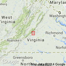
The Mobley Mountain Granite, here named, underlies Mobley Mountain in the southwestern corner of the Roseland district, Amherst Co., VA. It consists of fine- to medium-grained, massive granite with a pepper and salt appearance resulting from biotite patches disseminated through granular quartz and feldspar. The granite body is plug shaped under Mobley Mountain, and irregular smaller bodies, veins, and migmatites extend for 2 km in each direction away from the mountain. Intrudes the Turkey Mountain pluton of the Roses Mill Plutonic Suite. Age is Late Proterozoic, and is part of a belt of granites emplaced about 650 Ma.
Source: GNU records (USGS DDS-6; Reston GNULEX).

- Usage in publication:
-
- Mobley Mountain granite
- Modifications:
-
- Overview
- AAPG geologic province:
-
- Piedmont-Blue Ridge province
Summary:
Mobley Mountain mapped as informal unit. Described as faintly foliated, leucocratic to mesocratic, medium-grained, equigranular, epidote-, florencite-, garnet-, and fluorite-bearing muscovite-biotite granite. Cut by aplite and pegmatite dikes.
Source: GNU records (USGS DDS-6; Reston GNULEX).
- Usage in publication:
-
- Mobley Mountain Granite*
- Modifications:
-
- Geochronologic dating
- AAPG geologic province:
-
- Piedmont-Blue Ridge province
Summary:
Mobley Mountain Granite has Rb-Sr whole-rock isochron age of 652+/-22 Ma (Herz and Force, 1987).
Source: GNU records (USGS DDS-6; Reston GNULEX).
For more information, please contact Nancy Stamm, Geologic Names Committee Secretary.
Asterisk (*) indicates published by U.S. Geological Survey authors.
"No current usage" (†) implies that a name has been abandoned or has fallen into disuse. Former usage and, if known, replacement name given in parentheses ( ).
Slash (/) indicates name conflicts with nomenclatural guidelines (CSN, 1933; ACSN, 1961, 1970; NACSN, 1983, 2005, 2021). May be explained within brackets ([ ]).