The National Geologic Map Database is migrating to a new infrastructure. We apologize for any service disruptions during this process.
|
|---|


- Usage in publication:
-
- Mississinewa shale
- Modifications:
-
- Named
- Dominant lithology:
-
- Shale
- Limestone
- AAPG geologic province:
-
- Cincinnati arch
Summary:
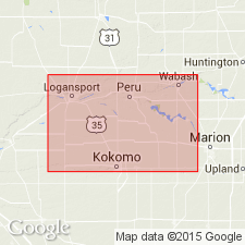
Name Mississinewa shale introduced in this report for drab to bluish-gray calcareous shale underlying Red Bridge limestone and forming basal exposed part of Niagaran in northern IN. Named for exposures along the Mississinewa River, at Wabash and Lagro. True base has not bee seen. At Wabash, 75 ft is exposed. 114 ft has been reported at Lagro on basis of well logs, but unit may be as much as 250 ft thick. Includes the "thick-bedded argillaceous limestone" and "hydraulic limestone" of Collett (1872) and equivalent formations. Also includes the "laminated shale," "cement rock," and probably the "hydraulic limestone" of Elrod and Benedict (1892). Age is Silurian (Niagaran).
Source: GNU records (USGS DDS-6; Reston GNULEX).
- Usage in publication:
-
- Mississinewa shale
- Modifications:
-
- Overview
- AAPG geologic province:
-
- Cincinnati arch
Summary:
Mississinewa shale is the lowest known formation of Niagaran age is northern IN. Late Rochester and early Lockport time are represented in it. It includes all strata beneath Red Bridge limestone member of Liston Creek Formation and base of Niagaran. Thickness probably 250 ft. Should basal portion prove to be limy, then term formation might be used. Underlying unit not known. It is conformable with the Liston Creek formation, but in places is disconformably overlain by younger formations.
Source: GNU records (USGS DDS-6; Reston GNULEX).

- Usage in publication:
-
- Mississinewa shale
- Modifications:
-
- Overview
- AAPG geologic province:
-
- Cincinnati arch
Summary:
Mississinewa shale is lowest Silurian formation recognized at surface in Indiana. At most exposures, it is blue-gray argillaceous dolomitic silty massive limestone that has conchoidal fracture and weathers to small rectangular blocks. Locally it is gray calcareous shale. Interbedding of shale and limestone are not common. Exposures of base not found. Normally overlain by Liston Creek limestone, but at Kokomo and Peru it is overlain by Kokomo limestone (Cayugan).
Source: GNU records (USGS DDS-6; Reston GNULEX).
- Usage in publication:
-
- Mississinewa shale member
- Modifications:
-
- Revised
- AAPG geologic province:
-
- Cincinnati arch
Summary:
Mississinewa shale reduced in rank to member and assigned to Wabash formation.
Source: GNU records (USGS DDS-6; Reston GNULEX).
- Usage in publication:
-
- Mississinewa Shale Member
- Modifications:
-
- Age modified
- AAPG geologic province:
-
- Cincinnati arch
Summary:
Mississinewa Shale Member of Wabash Formation of Salina Group is shown in this report to be Middle and Late Silurian. Underlies Late Silurian Liston Creek and Kokomo Limestone Members of Wabash; overlies Middle Silurian Pleasant Mills Formation.
Source: GNU records (USGS DDS-6; Reston GNULEX).

- Usage in publication:
-
- Mississinewa Shale Member
- Modifications:
-
- Overview
- AAPG geologic province:
-
- Cincinnati arch
Summary:
Distribution of the Mississinewa is somewhat spotty. Used until the 1970's only in central northern IN, the term was established in southern IN by Becker (1974) and by Becker and Droste (1978) who defined a vertical cutoff boundary against rocks of the Bainbridge Group. Unit is thus absent from the southwest corner of the state. Droste and Shaver (1982) extended the unit to some far northern counties. In its type area, the Mississinewa member consists of argillaceous dolomitic siltstone and silty dolomite in various shades of gray, fairly calcareous in places, and is dense to fine-grained and massive appearing in unweathered exposures. Although clay and quartz silt make up more than 50 percent of some samples, the designation of the Mississinewa as a shale is incorrect. Fissility is notably lacking from fresh exposures and cored sections. The bottom 30 ft is gradational into the brownish fine-grained dolomite of the Louisville. The member includes subordinate amounts of light-colored granular cherty dolomite and dolomitic limestone and also has a reef facies, commonly called the Huntington lithofacies. The lower Mississinewa contact with the Louisville in southern IN and Louisville-equivalent rocks in northern IN is conformable. Upper contact with the Liston Creek Limestone Member or Kokomo Member is also conformable. Correlates with the upper Moccasin Springs rocks of the Illinois basin, with a middle part of the Racine Formation of northern IL and eastern WI. Where the Mississinewa is thickest and occupies nearly the entire Wabash interval, some upper Mississinewa rocks correlate with some Liston Creek and Kokomo rocks. Contains stratigraphically useful index fossils that indicate an age within the Ludlovian Epoch spanning the Niagaran-Cayugan of the NY standard.
Source: GNU records (USGS DDS-6; Reston GNULEX).
For more information, please contact Nancy Stamm, Geologic Names Committee Secretary.
Asterisk (*) indicates published by U.S. Geological Survey authors.
"No current usage" (†) implies that a name has been abandoned or has fallen into disuse. Former usage and, if known, replacement name given in parentheses ( ).
Slash (/) indicates name conflicts with nomenclatural guidelines (CSN, 1933; ACSN, 1961, 1970; NACSN, 1983, 2005, 2021). May be explained within brackets ([ ]).