The National Geologic Map Database is migrating to a new infrastructure. We apologize for any service disruptions during this process.
|
|---|


- Usage in publication:
-
- Minersville shale member
- Modifications:
-
- Original reference
- Dominant lithology:
-
- Shale
- AAPG geologic province:
-
- Nemaha anticline
Summary:
Pg. 9. Minersville shale member of Friedrich shale formation. Defined as basal member of formation. Underlies Palmyra formation (new). Age is Late Pennsylvanian (Virgilian).
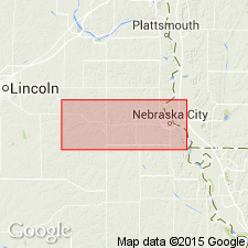
Type locality: in Missouri River bluffs near RR station at Minersville, Otoe Co., southeastern NE.
Source: US geologic names lexicon (USGS Bull. 1200, p. 2517).
- Usage in publication:
-
- Minersville shale member
- Modifications:
-
- Overview
- AAPG geologic province:
-
- Nemaha anticline
Summary:
Pg. 42. Minersville shale member of Friedrich shale formation. Overlies Morton limestone (new). Age is Late Pennsylvanian (Virgilian).
Source: US geologic names lexicon (USGS Bull. 1200, p. 2517).

- Usage in publication:
-
- Minersville shale member
- Modifications:
-
- Overview
Summary:
Pg. 14. Minersville shale member of Friedrich shale formation. Composed of red and grayish shales; locally sandy. Thickness 30 feet at Nebraska City and less southward in Nebraska and northeastern Kansas. Age is Late Pennsylvanian (Virgilian).
Source: US geologic names lexicon (USGS Bull. 1200, p. 2517).
- Usage in publication:
-
- Minersville shale
- Minersville shale member
- Modifications:
-
- Overview
- AAPG geologic province:
-
- Nemaha anticline
Summary:
Pg. 43-44. Minersville shale formation (Condra and Reed, 1938) or Minersville shale member of Friedrich shale formation (Moore, 1934). Included in Wabaunsee group. At Nebraska City, [Otoe County], Nebraska, largely bluish gray shale, with thin zones of red, argillaceous to sandy shale and some sandstone, about 30 to 32 feet thick. Overlies Morton limestone formation and underlies Palmyra limestone formation. South and southwest of Pawnee City, [Pawnee County], Nebraska, gray shale and sandstone, locally with some red near top, thickness 10 to 12 feet. Underlies Palmyra limestone member of Friedrich and overlies Morton limestone formation. Age is Late Pennsylvanian (Virgilian).
Source: Publication.
For more information, please contact Nancy Stamm, Geologic Names Committee Secretary.
Asterisk (*) indicates published by U.S. Geological Survey authors.
"No current usage" (†) implies that a name has been abandoned or has fallen into disuse. Former usage and, if known, replacement name given in parentheses ( ).
Slash (/) indicates name conflicts with nomenclatural guidelines (CSN, 1933; ACSN, 1961, 1970; NACSN, 1983, 2005, 2021). May be explained within brackets ([ ]).