

- Usage in publication:
-
- Minaville member
- Modifications:
-
- Original reference
- AAPG geologic province:
-
- Appalachian basin
Summary:
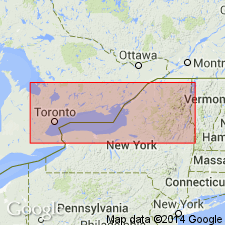
Pg. 268-270, pl. 4. Minaville Member of Canajoharie Formation. Lower member of Canajoharie. Includes two lowest graptolite zones of the Canajoharie. Composed predominately of black shales, somewhat silty in upper part, and a few metabentonites. Thickness about 750 feet; thins westward from type section. Underlies Fairfield member (new); overlies Shoreham limestone. Age is Middle Ordovician (Mohawkian).
Type section: along Chuctununda Creek between Amsterdam and Minaville. Named from Minaville, Florida Twp., Montgomery Co., east-central NY.
Source: US geologic names lexicon (USGS Bull. 1200, p. 2513).
For more information, please contact Nancy Stamm, Geologic Names Committee Secretary.
Asterisk (*) indicates published by U.S. Geological Survey authors.
"No current usage" (†) implies that a name has been abandoned or has fallen into disuse. Former usage and, if known, replacement name given in parentheses ( ).
Slash (/) indicates name conflicts with nomenclatural guidelines (CSN, 1933; ACSN, 1961, 1970; NACSN, 1983, 2005, 2021). May be explained within brackets ([ ]).