The National Geologic Map Database is migrating to a new infrastructure. We apologize for any service disruptions during this process.
|
|---|


- Usage in publication:
-
- Mina Formation
- Modifications:
-
- Named
- Dominant lithology:
-
- Volcaniclastics
- Sandstone
- AAPG geologic province:
-
- Great Basin province
Summary:
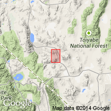
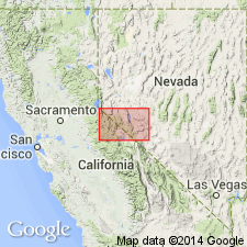
Named for town in Douglas Canyon. Type area designated as lower Douglas Canyon, sec.23 T6N R34E, Garfield Hills, 3 to 5 km southwest of town of Mina, Mineral Co, NV. Consists dominantly of volcanogenic turbidite, lesser chert, pelite, and quartz sandstone. Is over 1,000 m thick. Turbidite sequences are fining upward. Is extensively thrust-faulted forming nappes. Base is not exposed. Underlies with angular unconformity Gold Range Formation. Is Permian age on basis of K-Ar ages on hornblende ranging from 255.8 +/-6.0 Ma to 235 +/-5.9( Ma and fossil collection of fusulinids identified by P.P. Orkild and W.J. Carr.
Source: GNU records (USGS DDS-6; Menlo GNULEX).
- Usage in publication:
-
- Mina Formation*
- Modifications:
-
- Geochronologic dating
- AAPG geologic province:
-
- Great Basin province
Summary:
K-Ar ages on hornblende and sanidine from samples of Mina Formation collected in Excelsior Mountains southwest of Mina, NV, yielded ages of 267.5 +/-6.7, 261.4 +/-6.5, 245.5 +/-6.1, 240.3 +/-6.1, 229.9 +/-5.6, and 182.7 +/-4.6 Ma.
Source: GNU records (USGS DDS-6; Menlo GNULEX).
For more information, please contact Nancy Stamm, Geologic Names Committee Secretary.
Asterisk (*) indicates published by U.S. Geological Survey authors.
"No current usage" (†) implies that a name has been abandoned or has fallen into disuse. Former usage and, if known, replacement name given in parentheses ( ).
Slash (/) indicates name conflicts with nomenclatural guidelines (CSN, 1933; ACSN, 1961, 1970; NACSN, 1983, 2005, 2021). May be explained within brackets ([ ]).