

- Usage in publication:
-
- Millbach member
- Modifications:
-
- Named
- Dominant lithology:
-
- Limestone
- AAPG geologic province:
-
- Appalachian basin
Summary:
Named Millbach member of Conococheague formation. Unit is limestone sequence that stratigraphically overlies Schaefferstown member; top is drawn at base of first medium-gray siliceous dolomite bed of overlying Richland member. Distinguished from Schaefferstown member by presence of white to pinkish-gray crystalline limestone beds and less distinct shaly partings and bands in the medium-light-gray to medium-gray limestone beds; lithologically similar to Buffalo Springs member and is distinguished principally by stratigraphic position; a few thin sandstones and sandy limestones or dolomites are present; CRYPTOZOON reefs common. Width of outcrops suggests that thickness is in order of 500 to 550 feet; partial type section is 112 feet; neither top nor base exposed, but good exposures of CRYPTOZOON present. Age is Late Cambrian.
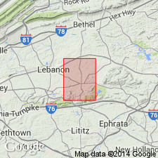
Named for Millbach, Lebanon Co., southeastern PA.
Source: Modified from GNU records (USGS DDS-6; Reston GNULEX).
- Usage in publication:
-
- Millbach formation
- Modifications:
-
- Revised
- AAPG geologic province:
-
- Appalachian basin
Summary:
Raised the Millbach to the Millbach formation of the Conococheague group on PA state geologic map.
Source: GNU records (USGS DDS-6; Reston GNULEX).
- Usage in publication:
-
- Millbach Formation*
- Modifications:
-
- Overview
- AAPG geologic province:
-
- Appalachian basin
Summary:
The Millbach Formation of the Conococheague Group consists of white to light-pinkish-gray limestone with laminae or thin beds of light-gray dolomite and medium-gray limestone. Unit is mappable across Lititz belt and western third of Mount Joy belt. Overlies Snitz Creek Formation and underlies Richland Formation, both of the Conococheague Group.
Source: GNU records (USGS DDS-6; Reston GNULEX).

- Usage in publication:
-
- Millbach Formation
- Modifications:
-
- Overview
- AAPG geologic province:
-
- Appalachian basin
Summary:
The Millbach Formation in the Lebanon Valley sequence of the Great Valley consists of pink to white and gray, finely laminated limestone and interbedded finely crystalline dolomite containing numerous stromatolitic limestone beds. Overlies Schaefferstown Formation and underlies Richland Formation.
Source: GNU records (USGS DDS-6; Reston GNULEX).
For more information, please contact Nancy Stamm, Geologic Names Committee Secretary.
Asterisk (*) indicates published by U.S. Geological Survey authors.
"No current usage" (†) implies that a name has been abandoned or has fallen into disuse. Former usage and, if known, replacement name given in parentheses ( ).
Slash (/) indicates name conflicts with nomenclatural guidelines (CSN, 1933; ACSN, 1961, 1970; NACSN, 1983, 2005, 2021). May be explained within brackets ([ ]).