The National Geologic Map Database is migrating to a new infrastructure. We apologize for any service disruptions during this process.
|
|---|


- Usage in publication:
-
- Miguelito Member
- Modifications:
-
- Named
- Biostratigraphic dating
- Dominant lithology:
-
- Claystone
- Siltstone
- Diatomite
- Sandstone
- AAPG geologic province:
-
- California Coast Ranges province
Summary:
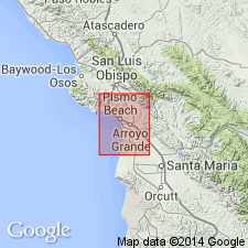
Named as second from lowermost member (of five) of Pismo Formation after San Miguelito Land Grant. Type section is on north limb of Pismo syncline on San Luis Obispo Creek, approximately 1 mi north of Squire Canyon, Pismo Beach 7.5' quad, San Luis Obispo Co., CA. Consists of brown-gray or greenish-gray claystone or siltstone with some diatomite and bituminous sandstone lenses. Is 2250 feet thick. Disconformably overlies Monterey Formation; interfingers with or overlies Edna Member (new) (Pismo Formation); underlies Gragg or Squire Member (both new of Pismo Formation). Based on megafossils age is late Miocene and early Pliocene.
Source: GNU records (USGS DDS-6; Menlo GNULEX).

- Usage in publication:
-
- Miguelito Member*
- Modifications:
-
- Adopted
- AAPG geologic province:
-
- California Coast Ranges province
Summary:
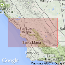
Miguelito Member of Pismo Formation of Hall (1973) is adopted. Shown on geologic map of Morro Bay South and port San Luis 7.5' quads, San Luis Obispo Co., CA, undivided with Edna Member of Pismo Formation. Four lithologies are shown separately. Age is Miocene and Pliocene based on fossils, some collected in adjoining Arroyo Grande 15' quad (Hall, 1973).
Source: GNU records (USGS DDS-6; Menlo GNULEX).
- Usage in publication:
-
- Miguelito Member*
- Modifications:
-
- Age modified
- Biostratigraphic dating
- AAPG geologic province:
-
- California Coast Ranges province
Summary:
Unit age given as late Miocene (only) in report area based on diatom and silicoflagellate assemblages from the unit.
Source: GNU records (USGS DDS-6; Menlo GNULEX).
For more information, please contact Nancy Stamm, Geologic Names Committee Secretary.
Asterisk (*) indicates published by U.S. Geological Survey authors.
"No current usage" (†) implies that a name has been abandoned or has fallen into disuse. Former usage and, if known, replacement name given in parentheses ( ).
Slash (/) indicates name conflicts with nomenclatural guidelines (CSN, 1933; ACSN, 1961, 1970; NACSN, 1983, 2005, 2021). May be explained within brackets ([ ]).