The National Geologic Map Database is migrating to a new infrastructure. We apologize for any service disruptions during this process.
|
|---|


- Usage in publication:
-
- Miguel formation*
- Modifications:
-
- Named
- Dominant lithology:
-
- Sandstone
- Shale
- AAPG geologic province:
-
- Orogrande basin
- Basin-and-Range province
Summary:
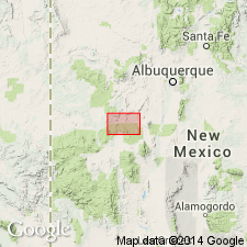
Miguel formation. Yellow sandstones, massive and persistent, also soft sandstones, drab and yellow sandy shales, a few beds of clay, and several beds of coal in upper half. Abundant invertebrate fossils and a few plant remains. Contains 4 persistent massive yellow sandstone members, 2 of which are here named, Bell Mountain sandstone member being applied to the one at top and Gallego sandstone member to the one near middle. The 2 lower sandstones may represent Tres Hermanos sandstone member of Lee. Thickness 2,080 feet. Underlies Chamiso formation and overlies Dakota sandstone. Benton fauna abundant. Is not exactly = Mancos shale, hence local name. Age is Late Cretaceous. Recognized in Alamaso Creek Valley [now Alamocita Creek] area, Socorro [and Catron] Cos., southwestern NM.
Named from Miguel Creek [now Miguel Chavez Canyon], which crosses the beds in northwest part of area [Alamocita Creek Valley], [Catron and] Socorro Cos., southwestern NM.
[Miguel Chavez Canyon and Alamocita Creek are in Catron County (est. Feb. 1921) and Socorro County, Magdalena quadrangle, scale 1:100,000.]
Source: US geologic names lexicon (USGS Bull. 896, p. 1367).
- Usage in publication:
-
- Miguel formation*†
- Modifications:
-
- Abandoned
Summary:
Abandoned as a name in Socorro Co, NM in the Orogrande basin. Is an upfaulted duplication of the Gallego sandstone member. Original definition was incorrect and beds measured and mapped in type were duplicated.
Source: GNU records (USGS DDS-6; Denver GNULEX).
For more information, please contact Nancy Stamm, Geologic Names Committee Secretary.
Asterisk (*) indicates published by U.S. Geological Survey authors.
"No current usage" (†) implies that a name has been abandoned or has fallen into disuse. Former usage and, if known, replacement name given in parentheses ( ).
Slash (/) indicates name conflicts with nomenclatural guidelines (CSN, 1933; ACSN, 1961, 1970; NACSN, 1983, 2005, 2021). May be explained within brackets ([ ]).