

- Usage in publication:
-
- Midvale Soil*
- Modifications:
-
- Named
- Dominant lithology:
-
- Soil
- AAPG geologic province:
-
- Wasatch uplift
Summary:
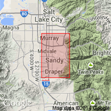
Named for the town of Midvale, Salt Lake Co, UT. Type locality is the crest of a narrow ridge between the lowermost part of Dry Creek and the Jordan River; extends half a mile southeast from tip of ridge within NE1/4 sec 11, T3S, R1W, Salt Lake Co, UT on the Wasatch uplift. Is 4 to 12 ft thick. Is a strongly developed submature soil that occurs on alluvium, colluvium, and lacustrine sediments of Draper age. Formed during the warm postpluvial interval (Altithermal age). Has two facies: 1) Noncalcic Brown (Pedalfer) facies in eastern part of area; and 2) Calcic Brown soil (Pedocal) facies in western part of area. Soil horizons described. Measured sections. Is older than eolian sand of late post-Draper age and Recent alluvium. The top of the Pleistocene interpreted to be the top of the Midvale. Correlation chart. Cross section.
Source: GNU records (USGS DDS-6; Denver GNULEX).
- Usage in publication:
-
- Midvale Soil*
- Modifications:
-
- Revised
- Overview
- AAPG geologic province:
-
- Wasatch uplift
Summary:
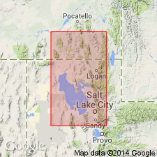
Overlies Draper Formation of Salt Lake Group. Underlies Ridgeland Formation (new) of Salt Lake Group. A section 33 cm thick measured in SW1/4 SE1/4 sec 20, T1S, R1W, Salt Lake Co, UT on Wasatch uplift. Ostracod fossils identified. Age not discussed.
Source: GNU records (USGS DDS-6; Denver GNULEX).
For more information, please contact Nancy Stamm, Geologic Names Committee Secretary.
Asterisk (*) indicates published by U.S. Geological Survey authors.
"No current usage" (†) implies that a name has been abandoned or has fallen into disuse. Former usage and, if known, replacement name given in parentheses ( ).
Slash (/) indicates name conflicts with nomenclatural guidelines (CSN, 1933; ACSN, 1961, 1970; NACSN, 1983, 2005, 2021). May be explained within brackets ([ ]).