

- Usage in publication:
-
- Middendorf [clays?]
- Modifications:
-
- Original reference
- Dominant lithology:
-
- Sand
- Clay
- AAPG geologic province:
-
- Atlantic Coast basin
Summary:
Pg. 68, 72, 75-81. Middendorf. White sands (25 feet), bed of dense, white and drab kaolin with waxy luster (fossiliferous), --harsh sands; varicolored cross-bedded fine-grained sands; thin seams of colored clay interlaminated with sands; gravel. Unconformably overlies Hamburg beds. Thickness at Aiken, South Carolina, 93 feet. Age is Late Cretaceous. [Detailed section given.]
Named from exposures near Middendorf, Chesterfield Co., coastal plain of SC.
Source: US geologic names lexicon (USGS Bull. 896, p. 1361).

- Usage in publication:
-
- Middendorf clays
- Modifications:
-
- Areal extent
- AAPG geologic province:
-
- Atlantic Coast basin
Summary:
Pg. 12, 13, 14. Middendorf clays, etc. Underlie Black Creek shale and overlie Upper Hamburg clays. Consist of white sands (25 feet), bed of dense white and drab kaolin with waxy luster (fossiliferous); harsh sands, varicolored cross-bedded fine-grained sands; thin seams of colored clay interlaminated with sands; gravel. The Lower Hamburg and Upper Hamburg and the Middendorf phases comprise sands, clays, and arkose which are exposed in upper three-fourths of Aiken County, South Carolina, in greater part of Lexington County, in lower part of Richland County, in body of Kershaw County, in lower part of Lancaster County, and in northerly part of Chesterfield County, South Carolina. Age is Late Cretaceous.
Source: US geologic names lexicon (USGS Bull. 896, p. 1361).

- Usage in publication:
-
- Middendorf deposits†
- Middendorf arkose member
- Middendorf formation
- Modifications:
-
- Overview
- AAPG geologic province:
-
- Atlantic Coast basin
Summary:
Later [post-1907], for several years the †Middendorf deposits (100 to 200 feet thick) were included in Black Creek formation as its basal member, under the name Middendorf arkose member. (See additional explanation under Black Creek formation.) Sill later they were treated as a distinct formation unconformably below the Black Creek formation and unconformably above the crystalline rocks, the Hamburg clays of western South Carolina having been found to be same as Middendorf deposits of eastern South Carolina. Still later the Middendorf and Hamburg deposits were proved to be same as Tuscaloosa formation, and both Middendorf and Hamburg were abandoned (See C.W. Cooke, USGS Bull. 867, 1936. Cooke considers it possible that further work in South Carolina and North Carolina may result in differentiating some older deposits from those now called Tuscaloosa formation in those States.)
Source: US geologic names lexicon (USGS Bull. 896, p. 1361).
- Usage in publication:
-
- Middendorf formation†
- Modifications:
-
- Abandoned
- AAPG geologic province:
-
- Atlantic Coast basin
Summary:
Pg. 17. †Middendorf formation. Local names Hamburg and Middendorf were applied by Sloan (1904) to clays and sands in South Carolina that were supposed to be of Lower Cretaceous age. Berry, 1916 (USGS Prof. Paper 84), on basis of fossil plants, transferred Middendorf beds to Upper Cretaceous under name Middendorf arkose member of Black Creek formation. Cooke, 1926 (USGS Prof. Paper 140-E) proposed to restore Middendorf to formation rank and to include in it the Hamburg beds. At that time, [Cooke] correlated the Middendorf with Tuscaloosa formation of Alabama but deemed local designation necessary, because beds having Middendorf aspect in Georgia might represent a period of time somewhat longer than that of the Tuscaloosa and might include all or part of Eutaw time. Recent work shows that Middendorf in Georgia is quite different from Eutaw formation but apparently identical with the Tuscaloosa. As local name for the beds in South Carolina and Georgia is unnecessary, older name Tuscaloosa is here substituted for name Middendorf formation.
Source: US geologic names lexicon (USGS Bull. 1200, p. 2486-2487).
- Usage in publication:
-
- Middendorf member
- Modifications:
-
- Reinstated
Summary:
Pg. 2181-2184. In South Carolina, Middendorf member of Black Creek formation (herein revived as equivalent of upper part of Cooke's 1936 Tuscaloosa formation) has been shown to contain plant remains essentially equivalent to those of the lower Black Creek formation of North Carolina; lower part of Cooke's Tuscaloosa is herein referred to as Lower Cretaceous(?) (undifferentiated). [Age is Late Cretaceous.]
Source: US geologic names lexicon (USGS Bull. 1200, p. 2486-2487).
- Usage in publication:
-
- Middendorf Formation
- Modifications:
-
- Revised
- AAPG geologic province:
-
- Atlantic Coast basin
Summary:
Pg. 211, 213, 226, 228. Middendorf Formation included in Lumbee Group (new). Recognized in North Carolina and South Carolina. [Age is Late Cretaceous.]
Source: GNC index card files (USGS-Reston).
- Usage in publication:
-
- Middendorf Formation
- Modifications:
-
- Areal extent
- AAPG geologic province:
-
- Atlantic Coast basin
- South Georgia sedimentary province
Summary:
The Cretaceous section in the subsurface at the Savannah River site is divided into (ascending) Cape Fear, Middendorf, Black Creek, and Steel Creek (new) Formations. The Middendorf is composed mostly of tan, gray, and yellow, moderately well to well-sorted, medium and coarse quartz sand. Pebbly zones common; some clay clasts. Local cross-bedding in lower part. A kaolinitic clay or clay-and-interbedded sand zone forms upper 50 ft of unit. Contact with Cape Fear is marked by a pebbly zone. Unit is 100 ft thick near northwestern boundary of area and 180 ft thick near southeastern boundary. Wood fragments and scarcity of marine fossils suggest deposition in fluvial and deltaic environments. Santonian age indicated by assemblages of spores, pollen, and dinoflagellates. Correlates with upper part of Eutaw Formation in GA and AL.
Source: GNU records (USGS DDS-6; Reston GNULEX).
- Usage in publication:
-
- Middendorf Formation*
- Modifications:
-
- Revised
- Age modified
- Biostratigraphic dating
- AAPG geologic province:
-
- Atlantic Coast basin
Summary:
Pg. 11 (fig. 8), 12-13, 17, 29, 31 (fig. 22), 33. Middendorf Formation. Occurs in subsurface between 1,754 and 1,861 feet in Clubhouse Crossroads No. 1 drill core, near Clubhouse Crossroads, Dorchester County, southeastern South Carolina. Sediments previously included in the basal part of Black Creek Formation by Hazel and others (1977) and Gohn and others (1977). Consists mostly of coarse sands and dark-gray carbonaceous clays. Thickness 107 feet. Overlies Cape Fear Formation; underlies Shepherd Grove Formation (new). Fossils. Age is Late Cretaceous (middle Santonian; Austinian Provincial Age; DICARINELLA CONCAVATA to D. ASYMETRICA planktic foram zone, CALCULITES OBSCURUS (NC17) calcareous nannofossil zone).
The sediments previously assigned to Middendorf Formation (1,860 to 2,268 feet) by Hazel and others (1977) and Gohn and others (1977) are reallocated to Cape Fear Formation.
Source: Publication.
- Usage in publication:
-
- Middendorf Formation*
- Modifications:
-
- Biostratigraphic dating
- AAPG geologic province:
-
- Atlantic Coast basin
Summary:
Middendorf in Myrtle Beach, SC, corehole consists of two lithologic subunits. Lower part is dense, olive-gray, calcareous, silty clay (68 ft thick); upper part is calcareous, clayey and silty, fine sand containing abundant bivalves. Overlying 15 ft of grayish-olive-green, calcareous, silty and sandy clay is assigned to Shepherd Grove Formation. Overlies clay and sand of Cape Fear Formation. Planktic Foraminifera genera in the Middendorf include ARCHAEOGLOBIGERINA, DICARINELLA, GLOBOTRUNCANA, HEDBERGELLA, HETEROHELIX, MARGINOTRUNCANA, and ROSITA, all of which indicate a Santonian age. Age also supported by calcareous nannofossil LITHASTRINUS SEPTENARIUS; ostracodes BRACHYCYTHERE NAUSIFORMIS, "CYTHEREIS" VECLITELLA, SCHIZOPTOCYTHERE? COMPRESSA, and VEENIA QUADRIALIRA; and oyster OSTREA CRETACEA Morton. Middendorf correlates with Eutaw Formation of AL as suggested by a comparison of their respective fauna and flora (Sohl and Smith, 1980).
Source: GNU records (USGS DDS-6; Reston GNULEX).
- Usage in publication:
-
- Middendorf Formation*
- Modifications:
-
- Mapped 1:100k
- Dominant lithology:
-
- Sand
- Silt
- Clay
- AAPG geologic province:
-
- Atlantic Coast basin
Summary:
Pg. 5, 7, 14, 21, geol. map. Middendorf Formation. Exposed along upper reaches of Savannah River and its tributaries. Consists of fining-upwards cycles of coarse sands grading upward into silt and clay layers; typically at tops of silt and clay beds is a zone of iron oxidation. Large-scale cross-bedding common. Generally, top of formation marked by several thin (1 to 1.5 m; 3 to 5 feet) beds of sandy kaolin. Underlies Black Creek Group. Overlies (in subsurface only) Cape Fear Formation. Age is Late Cretaceous (Santonian). Samples from carbonaceous clay yielded a pollen zone V (subzone C) assemblage (Doyle and Robbins, 1977, Palynology, v. 1; Christopher, 1982a, Georgia Geol. Survey Inf. Circ., no. 53, 1982b, Jour. Paleo., v. 56, no. 2).
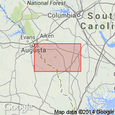
Best exposure in quadrangle: Augusta Sand and Gravel Company mine on east side of U.S. Route 278 just south of Horse Creek near Clearwater, SC.
Source: Publication.
- Usage in publication:
-
- Middendorf Formation*
- Modifications:
-
- Areal extent
- AAPG geologic province:
-
- Atlantic Coast basin
Summary:
Middendorf Formation. Name has been applied to a variety of units in coastal plain of South Carolina, eastern Georgia, and southern North Carolina since 1904. Authors suggest restricting use of Middendorf to area surrounding type section. At type section, consists of (ascending): (1) coarse-grained, cross-bedded, clayey sand, [7+ feet]; (2) laminated fine-grained sand and clay, [7+ feet]; and (3) massive clayey sand containing an organic-rich layer at top, [3+ feet]. Considered equivalent to either the Bladen Formation, or to parts of both the Bladen and Peedee Formations, based on stratigraphic and structural position. Interpreted to represent two depositional environments, fluvial (lower part) and marginal marine (upper part). Age is considered Late Cretaceous (Campanian to Maastrichtian?).
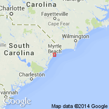
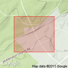
Type section: McKennon railroad stop along the Seabord Coast Line, approx. 2 mi northeast of community of Middendorf, Lat. 34 deg. 32 min. 59 sec. N., Long. 80 deg. 07 min. 48 sec. W., [Middendorf 7.5-min quadrangle], Chesterfield Co., coastal plain of SC.
Source: Publication.
- Usage in publication:
-
- Middendorf Formation
For more information, please contact Nancy Stamm, Geologic Names Committee Secretary.
Asterisk (*) indicates published by U.S. Geological Survey authors.
"No current usage" (†) implies that a name has been abandoned or has fallen into disuse. Former usage and, if known, replacement name given in parentheses ( ).
Slash (/) indicates name conflicts with nomenclatural guidelines (CSN, 1933; ACSN, 1961, 1970; NACSN, 1983, 2005, 2021). May be explained within brackets ([ ]).