The National Geologic Map Database is migrating to a new infrastructure. We apologize for any service disruptions during this process.
|
|---|


- Usage in publication:
-
- Merced series
- Modifications:
-
- Original reference
- AAPG geologic province:
-
- California Coast Ranges province
Lawson, A.C., 1893, The post-Pliocene deposits of the coast of southern California: University of California, Bulletin of the Department of Geology, v. 1, no. 4, p. 115-160.
Summary:
Pg. 142-151; 1895, USGS 15th Ann. Rpt., p. 459-463. Merced series. Present in San Francisco Bay region, western California. For convenience the Pliocene rocks here referred to will be designated Merced series, from Lake Merced, which lies in a structural or synclinal depression of the Pliocene terrane, to south of the city. The base of the series is observable at Mussel Rock. Basal bed is a stratum of partially carbonized forest material. Is a local or delta accumulation. Very fossiliferous. The delta gravels on the San Benito [on p. 153 casually called San Benito gravels] are direct equivalents of Merced series.
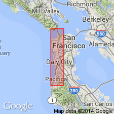
Named from Lake Merced, south of San Francisco, western CA. Exposed in sea-cliff which extends from Lake Merced, near San Francisco, to Mussel Rock about 8 mi south of Point Lobos at entrance to the gate. Thickness in cliff section 5,834 ft.
Source: US geologic names lexicon (USGS Bull. 896, p. 1349; USGS Bull. 1200, p. 2463-2464).

- Usage in publication:
-
- Merced formation*
- Modifications:
-
- Overview
- AAPG geologic province:
-
- California Coast Ranges province
Summary:
The Merced formation (marine) in San Francisco region rests unconformably on Franciscan rocks or on an ancient alluvium of post-Franciscan and pre-Merced age. Is considered = nonmarine Orinda formation, which lies conformably on Pinole tuff. In Santa Cruz region the Merced rests on Purisima formation. It is considered older than Berkeley group. (See USGS San Francisco folio, no. 193.)
This formation is now [ca. 1938] being assigned to middle Pliocene by California geologists. (See E. Dorf, Carnegie Inst. Wash. Pub., no. 412, p. 7, 1933.)
Source: US geologic names lexicon (USGS Bull. 896, p. 1349).
- Usage in publication:
-
- Merced formation*
- Modifications:
-
- Overview
- Dominant lithology:
-
- Sandstone
- Conglomerate
- Shale
- Siltstone
- AAPG geologic province:
-
- California Coast Ranges province
Summary:
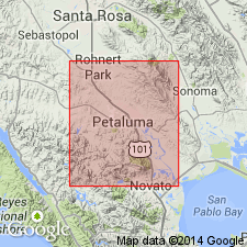
Pg. 622-627. Merced Formation. In Petaluma region [western California], upper Pliocene Merced is represented by both marine and fresh-water sediments. Former consists chiefly of fine-grained generally massive quartz-feldspathic sandstone, conglomerate, and clay shale. Latter consists of fluviatile conglomerates and sandstones of varying coarseness accompanied in many places by siltstones and clays. Marine Merced, about 1,500 feet thick, rests unconformably upon the Franciscan over entire area, except in southeastern corner, where west of Penngrove and Petaluma it is apparently conformable upon Sonoma volcanics which, in turn, are unconformable upon Franciscan group and Petaluma formation. Fresh-water deposits occur north of Santa Rosa and rest in conformable depositional contact upon Sonoma volcanics represented here by basalt.
Source: US geologic names lexicon (USGS Bull. 1200, p. 2463-2464).
- Usage in publication:
-
- Merced formation*
- Modifications:
-
- Areal extent
- AAPG geologic province:
-
- Northern Coast Range province
Summary:
Pg. 16 (table 3), 92-94. Merced formation. In area of this report [Coast Ranges north of San Francisco Bay, western California], the Merced is composed of marine sandstones and sandy shales usually less than 300 feet thick and probably equivalent to lower Merced of type section. South of Petaluma on west side of Burdell Mountain, [Marin County], Merced is interbedded with Sonoma volcanics. Age is Pliocene.
Source: US geologic names lexicon (USGS Bull. 1200, p. 2463-2464).
- Usage in publication:
-
- Merced formation*
- Modifications:
-
- Areal extent
- AAPG geologic province:
-
- California Coast Ranges province
Summary:
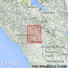
Pg. 11 (fig. 2), 23-25, pl. 1. Merced formation. In Healdsburg quadrangle [western California], the limited exposures of Merced are light-gray massive- to thick-bedded uniformly medium-grained sandstone that weathers pale buff; not cemented. Grades upward into nonmarine Sonoma sands and gravels, contact not precisely located. Minimum thickness of 500 feet estimated for Wilson Grove area. In Wilson Grove area, Merced strata conformably overlie 200 feet of Sonoma tuff; they are in turn overlain conformably by Sonoma sandstone and conglomerate; thus Merced here is marine wedge interbedded with Sonoma group. Northeast of Rio Dell, overlies Franciscan with profound unconformity. Merced blankets Franciscan terrane west of Llano de Santa Rosa south of Russian River, and is preserved in structural lows along San Andreas rift at various points southward to Golden Gate. In Healdsburg quadrangle and adjacent areas to south, its eastern extent has been controlled by western flanks of coeval Sonoma volcanics.
Source: US geologic names lexicon (USGS Bull. 1200, p. 2463-2464).
- Usage in publication:
-
- Merced formation*
- Modifications:
-
- Age modified
- AAPG geologic province:
-
- California Coast Ranges province
Summary:
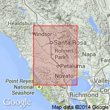
Pg. 26 (table 6), 38-47, pls. 1, 3, 4. Merced formation. Described in Santa Rosa and Petaluma Valley areas [western California] where it consists of medium- to fine-grained fossiliferous marine sand, sandstone, and silty clay, with minor interbedded gravel and pebbly beds; tuffaceous in part. Thickness 0 to about 2,000 feet. Interbedded with Sonoma volcanics and Glen Ellen formation. Includes part of Sonoma group of Gealey (1950 [1951]). In much of the area, unconformably overlies Franciscan and Knoxville, but, in western part of the area, is in fault contact with them. In some places, overlies Petaluma formation with marked angular unconformity. [Age is] Pleistocene(?) and late Pliocene. In general, Merced time is believed to span time interval occupied by Sonoma volcanics of Pliocene age and Glen Ellen formation of Pliocene(?) and Pleistocene age.
Source: US geologic names lexicon (USGS Bull. 1200, p. 2463-2464).
- Usage in publication:
-
- Merced formation*
- Modifications:
-
- Areal extent
- AAPG geologic province:
-
- California Coast Ranges province
Summary:
Pg. 147-198. Type Merced, approximately 5,000 feet thick, is mostly gray and brown, soft, friable sandstone; largely deposited in a marine shallow water coastal embayment environment. Molluscan and crustacean species indicate deposition from middle Pliocene through early Pleistocene time. Fossils and lithology indicate that "Merced" formation of Pillar Point is of middle Pliocene age and part of Purisima formation. Only a small part may be correlative with type Merced.
Source: US geologic names lexicon (USGS Bull. 1200, p. 2463-2464).

- Usage in publication:
-
- Merced Formation*
- Modifications:
-
- Geochronologic dating
- AAPG geologic province:
-
- California Coast Ranges province
Summary:
Pg. 8, 9, geologic time scale (inside front cover). Merced Formation. Samples from a 2.7-m-thick water-lain, vitric-crystal tuff interbedded within upper part of formation, in San Francisco South quadrangle, San Mateo County, California, yielded K-Ar ages (plagioclase): 2.2 +/-0.3 Ma (too old), 1.2 +/-0.5 Ma, 0.7 +/- 0.5 Ma, and 0.46 +/-0.19 Ma. Ages calculated using decay constants of Steiger and Jager, 1977 (Earth Planet. Sci. Letters, v. 36, p. 359-362). Correlations suggest probable age between 1.1 to 0.4 Ma and stratigraphic relations suggest probable age <2.2 Ma. Age agrees with other ages obtained from correlated tuffs (Sarna-Wojcicki, 1976, USGS Prof. Paper 972). [Quaternary, based on time scale of Berggren, 1972, Lethaia, v. 5, no. 2, p. 195-215.]
Source: Publication.
For more information, please contact Nancy Stamm, Geologic Names Committee Secretary.
Asterisk (*) indicates published by U.S. Geological Survey authors.
"No current usage" (†) implies that a name has been abandoned or has fallen into disuse. Former usage and, if known, replacement name given in parentheses ( ).
Slash (/) indicates name conflicts with nomenclatural guidelines (CSN, 1933; ACSN, 1961, 1970; NACSN, 1983, 2005, 2021). May be explained within brackets ([ ]).