The National Geologic Map Database is migrating to a new infrastructure. We apologize for any service disruptions during this process.
|
|---|


- Usage in publication:
-
- Memphis sandstone
- Modifications:
-
- Original reference
- Dominant lithology:
-
- Sandstone
- AAPG geologic province:
-
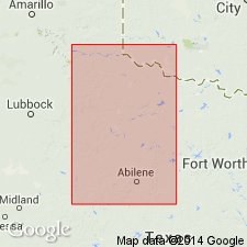
- Palo Duro basin
Summary:
Pg. 953, pl. 10. Memphis sandstone. A fossiliferous limy pink to red sandstone is present in Hall County approx. 250 feet above base of Whitehorse sandstone. Although similar in appearance to Verden "channel" sandstone of Oklahoma, the authors have called this bed Memphis sandstone, from buttes formed by it near Memphis, the county seat of Hall County, central northern Texas. Is 3 to 10 feet thick and similar in general characteristics to Verden sandstone except that it crops in belt 10 or 12 miles wide, and is much higher in geologic section, the Oklahoma member being in upper part of Dog Creek shale. Most southerly outcrop of this bed is in northern Motley County, near town of Northfield. [Age is Permian.]
[GNC remark (ca. 1930, US geologic names lexicon, USGS Bull. 896, p. 1343): Replaced by Dozier sandstone member of Peacock formation, q.v.]
Source: US geologic names lexicon (USGS Bull. 896, p. 1343).
- Usage in publication:
-
- Memphis sandstone
- Modifications:
-
- Areal extent
- AAPG geologic province:
-
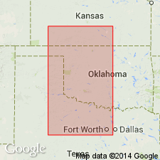
- Anadarko basin
- Palo Duro basin
- Permian basin
Summary:
Pg. 703. Believes Memphis sandstone is a continuation of Dozier Hills, which are channel deposits, and that it marks base of his Custer formation, which he assigned to Lower Triassic.
Source: US geologic names lexicon (USGS Bull. 896, p. 1343).

- Usage in publication:
-
- Memphis sandstone†
- Modifications:
-
- Abandoned
- AAPG geologic province:
-
- Palo Duro basin
- Permian basin
Summary:
Pg. 167. †Memphis sandstone. The name Memphis sandstone has been abandoned by the USGS and Dozier sandstone substituted for it.
Source: US geologic names lexicon (USGS Bull. 896, p. 1343).
For more information, please contact Nancy Stamm, Geologic Names Committee Secretary.
Asterisk (*) indicates published by U.S. Geological Survey authors.
"No current usage" (†) implies that a name has been abandoned or has fallen into disuse. Former usage and, if known, replacement name given in parentheses ( ).
Slash (/) indicates name conflicts with nomenclatural guidelines (CSN, 1933; ACSN, 1961, 1970; NACSN, 1983, 2005, 2021). May be explained within brackets ([ ]).