

- Usage in publication:
-
- Meiklejohn formation*
- Modifications:
-
- Named
- Dominant lithology:
-
- Claystone
- AAPG geologic province:
-
- Great Basin province
Summary:
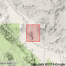
Meiklejohn formation. Measured section (type section), bounded top and bottom by thrust faults, is 3,200 feet thick, and consists chiefly of silty claystone with intercalated zones of chert, shale, coarser clastics, and carbonate rocks. Rocks in measured section divided into lower, middle, and upper units 1,000, 800, and 1,400 feet thick respectively. Two fragmentary sections, also bounded by faults, crop out west and northeast of Meiklejohn Peak. Overlies Fluorspar Canyon formation (new). Age is Late Mississippian.
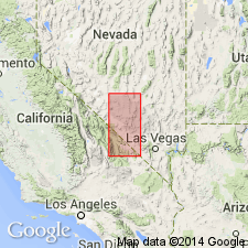
Type section: southeast flank of Meiklejohn Peak, Bare Mountain 15-min quadrangle, Nye Co., southern NV. Named from Meiklejohn Peak.
Source: US geologic names lexicon (USGS Bull. 1350, p. 481).
- Usage in publication:
-
- Meiklejohn Formation†
- Modifications:
-
- Abandoned
- AAPG geologic province:
-
- Great Basin province
Summary:
Meiklejohn Formation abandoned; its rocks now assigned to Eleana Formation. [Adopted by the USGS (see Changes in stratigraphic nomenclature, 1973, USGS Bull. 1395-A, p. A26-A27).]
Source: Changes in stratigraphic nomenclature, 1973 (USGS Bull. 1395-A, p. A26-A27).
For more information, please contact Nancy Stamm, Geologic Names Committee Secretary.
Asterisk (*) indicates published by U.S. Geological Survey authors.
"No current usage" (†) implies that a name has been abandoned or has fallen into disuse. Former usage and, if known, replacement name given in parentheses ( ).
Slash (/) indicates name conflicts with nomenclatural guidelines (CSN, 1933; ACSN, 1961, 1970; NACSN, 1983, 2005, 2021). May be explained within brackets ([ ]).