The National Geologic Map Database is migrating to a new infrastructure. We apologize for any service disruptions during this process.
|
|---|


- Usage in publication:
-
- Medicine Lodge gypsum
- Modifications:
-
- Named
- Dominant lithology:
-
- Gypsum
- AAPG geologic province:
-
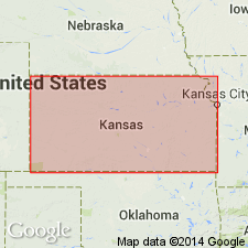
- Sedgwick basin
Summary:
Named as basal unranked unit of newly named Cave Creek gypsums (or formation) of Salt Fork division (new) of the Cimarron series (new); named for exposures in the valley of the Medicine Lodge River, Barber Co, KS. No type locality designated although one locality was measured on Cave creek at Comanche cave; at that spot is 25-30 ft thick. Occurs in KS from Harper, Harper Co, to Medicine Lodge in Barber Co, both in Sedgwick basin. Is a persistent bed of prominent, continuous massive gypsum, mostly grayish-white mottled with feebly defined dark spots. Thickness varies from 12 to 30 ft. Overlies Flower-pot shales (new) of Salt Fork division and underlies Shimer gypsum (new, unranked) of Cave Creek formation, both of Salt Fork division of the Cimarron series. Of Permian age.
Source: GNU records (USGS DDS-6; Denver GNULEX).
- Usage in publication:
-
- Medicine Lodge gypsum member
- Modifications:
-
- Revised
- AAPG geologic province:
-
- Sedgwick basin
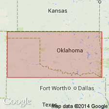
- Anadarko basin
Summary:
Is the third member from base of five named members of Blaine division (new). Formerly part of Cave Creek formation. Overlies Magpie dolomite member (new) of Blaine. Underlies Altona dolomite member (new). Is the most conspicuous gypsum ledge in the redbed section. Extends uninterruptedly from head of Medicine Lodge River, Barber Co, KS in the Sedgwick basin south to Canadian Co, OK in the Anadarko basin. At most places the ledge caps the Gypsum Hills. Permian age.
Source: GNU records (USGS DDS-6; Denver GNULEX).
For more information, please contact Nancy Stamm, Geologic Names Committee Secretary.
Asterisk (*) indicates published by U.S. Geological Survey authors.
"No current usage" (†) implies that a name has been abandoned or has fallen into disuse. Former usage and, if known, replacement name given in parentheses ( ).
Slash (/) indicates name conflicts with nomenclatural guidelines (CSN, 1933; ACSN, 1961, 1970; NACSN, 1983, 2005, 2021). May be explained within brackets ([ ]).