

- Usage in publication:
-
- Meadow marble
- Modifications:
-
- Original reference
- Dominant lithology:
-
- Marble
- AAPG geologic province:
-
- Appalachian basin
Summary:
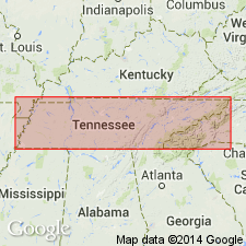
Pg. 39-40, 63-65, and map. The marble here called Meadow marble has not been mapped hitherto. Its outcrop makes its appearance about 2 miles southwest of Meadow Station and ends near Miser, 2.75 miles northeast of Friendsville, central Tennessee. It consists of light gray and pink marble, identical in appearance with corresponding variety of Holston marble formation. It has its best development from Meadow Station to point southeast of Kiser, a distance of about 2.5 miles. Thickness roughly estimated at 200 to 300 feet. Difference of opinion exists as to stratigraphic position of this marble, some, including writer, holding it to constitute a lentil near middle of Tellico formation, while others consider it to be at base of overlying Ottosee (Sevier). The latter view makes it correspond in position with the variegated marble at Vestal, whereas marble identical with the latter outcrops 0.75 mile east of the Meadow with several hundred feet of typical Tellico intervening between the two marble formations.
Source: US geologic names lexicon (USGS Bull. 896, p. 1330-1331).

- Usage in publication:
-
- Meadow marble member*
- Modifications:
-
- Overview
- AAPG geologic province:
-
- Appalachian basin
Summary:
Meadow marble member of Sevier shale. Adopted by the USGS as a local basal member of Sevier shale in eastern part of Loudon County and western part of Blount County, central Tennessee. Age is Early Ordovician (Chazy).
Named from exposures near Meadow Station, Loudon Co., central TN.
[According to note in GNC file dated November 13, 1922, C. Butts considered the Meadow to be younger that the Holston limestone, although Gordon claimed the Meadow and the Holston to be the same unit.]
Source: US geologic names lexicon (USGS Bull. 896, p. 1330-1331); GNU records (USGS DDS-6; Reston GNULEX).
- Usage in publication:
-
- Meadow marble member*
- Modifications:
-
- Areal extent
- AAPG geologic province:
-
- Appalachian basin
Summary:
Pg. 78. Meadow marble member of Sevier shale. Name applied to calcarenite lens near base of Sevier southwest of Friendsville, central Tennessee.
Source: US geologic names lexicon (USGS Bull. 1200, p. 2440).
For more information, please contact Nancy Stamm, Geologic Names Committee Secretary.
Asterisk (*) indicates published by U.S. Geological Survey authors.
"No current usage" (†) implies that a name has been abandoned or has fallen into disuse. Former usage and, if known, replacement name given in parentheses ( ).
Slash (/) indicates name conflicts with nomenclatural guidelines (CSN, 1933; ACSN, 1961, 1970; NACSN, 1983, 2005, 2021). May be explained within brackets ([ ]).