

- Usage in publication:
-
- McKnight formation
- Modifications:
-
- Original reference
- Dominant lithology:
-
- Shale
- Limestone
- Chert
- AAPG geologic province:
-
- Ouachita folded belt
Summary:
Pg. 15-23; 1962, IN Contributions to the geology of south Texas: San Antonio, South Texas Geol. Soc., p. 87-98. McKnight formation of Atascosa group (new). A black shale or shaly siliceous limestone with anhydrite nodules and veinlets and thin chert beds. Overlies Edwards "B" and underlies Pryor member (new) of Georgetown formation and Edwards "A". Formation pinches out in eastern part of Zavala and Dimmit Counties and also pinches out close to the reef trend in northern Webb County. Northern limit lies in Uvalde and Kinney Counties and southern tip of Val Verde County. Name was first used by Hedwig Kniker in report of Producers of Maryland Oil Company, but was never defined in publication. Imlay (1945, AAPG Bull., v. 29, no. 10) assigned the beds to the Kiamichi. Name McKnight is preferable to name Kiamichi for the sequence of black shaly limestone in Maverick basin because of lithologic difference and deposition in a different basin from the Kiamichi. McKnight divided into three unnamed members. Age is Early Cretaceous (Comanche).
[Type locality and origin of name not stated.]
Source: US geologic names lexicon (USGS Bull. 1350, p. 454-455).
- Usage in publication:
-
- McKnight Formation
- Modifications:
-
- Revised
- Reference
- Areal extent
- AAPG geologic province:
-
- Ouachita folded belt
Summary:
p. 285-306. McKnight Formation. [Atascosa Group not used in this report.] Winter (1961) revived name McKnight for subsurface usage west of San Marcos platform. Unit has been extended into outcrop and name McKnight is herewith applied to surface exposures. Maximum outcrop thickness about 145 feet and section divisible into lower and upper thin-bedded limestone units separated by petroliferous 25-foot section of black laminated fissile clayey lime mudstone beds. The 70-foot lower section of brown shell fragments and pellet grainstones with thin chert layers is overlain by lighter mudstones with solutioned zones and collapse breccia. The 55-foot upper unit, as exposed at Chalk Bluff, is mostly thin-bedded mudstone; it also contains thin chert layers, solution zones, and another collapse breccia bed near middle. Overlies West Nueces Formation (new); underlies Salmon Peak Formation (new). Age is Early Cretaceous (Comanche).
Although intent of Winter (1961) is implicit, and many requirements of Stratigraphic Code have been met, Winter designated no interval (type section) in any specified well (type locality), and name thus lacks critical elements of definition for formal establishment as subsurface unit. Although unit is now known to crop out and an outcrop type section could be defined (and another name proposed), informal priority and familiar usage of McKnight would seem to favor retaining subsurface name and defining a subsurface type section. No decision, in conjunction with subsurface workers, has been attempted to designate namesake well as type well or to specify the interval.
Reference section (composite; outcrop): lower part is from a bluff on right bank of West Nueces River on Bitter Ranch, 1.2 mi south of Tularosa road intersection with the "river road" northeastern Kinney Co., southern TX; upper part is from basal 75 ft of Chalk Bluff on Nueces River, 2 mi south of Nineteen Mile Crossing of State Highway 55 (Uvalde-Rock Springs road), western Uvalde Co., southern TX. Total section is exposed only in reference section. In Mexico the McKnight encircles the southeastern end of the Serrania del Burro.
Source: US geologic names lexicon (USGS Bull. 1350, p. 454-455).

- Usage in publication:
-
- McKnight Formation
- Modifications:
-
- Areal extent
- Mapped 1:250k
- Dominant lithology:
-
- Limestone
- Shale
- AAPG geologic province:
-
- Ouachita folded belt
Summary:
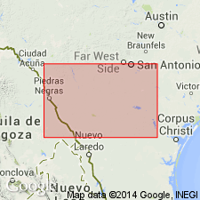
Is Lower Cretaceous formation mapped in northeastern Kinney and northwestern Uvalde Cos, TX (Ouachita tectonic belt province). Overlies West Nueces Formation. Overlain by Salmon Peak Limestone. Map unit described as limestone and shale; upper 55 ft--lime mudstone, thin-bedded, locally contains chert layers, solution zones, and collapse breccia; intermediate 25 ft--argillaceous lime mudstone, laminated, fissile, black; lower 70 ft--limestone, granular, thin chert layers, abundant shell fragments and pellets, overlain by lime mudstone with solution zone and collapse breccia; total thickness 150 ft. Is not mapped north of [what appears to be an arbitrary] east-west line that separates the unit from the Devils River Limestone. In map explanation, is schematically depicted to be equivalent to Sue Peaks Limestone, middle part of Devils River Limestone, upper part of Fort Terrett Member of Edwards Limestone, and lower part of Segovia Member of Edwards.
Source: GNU records (USGS DDS-6; Denver GNULEX).

- Usage in publication:
-
- McKnight Formation
- Modifications:
-
- Areal extent
- Mapped 1:250k
- Dominant lithology:
-
- Limestone
- Shale
- AAPG geologic province:
-
- Ouachita folded belt
Summary:
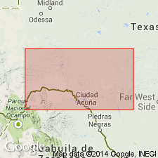
Is Lower Cretaceous formation mapped in western Uvalde Co, TX (Ouachita tectonic belt province). Is not mapped north of or northeast of apparent arbitrary limit in the vicinity of Deep Creek; Devils River Limestone (Lower Cretaceous) is mapped north and northeastward. Is shown correlative with middle part of Devils River Limestone and with middle part of Edwards Limestone (lower part of Segovia Member and upper part of Fort Terrett Member). Overlies West Nueces Formation (Lower Cretaceous); overlain by Salmon Peak Limestone (Lower Cretaceous). Map unit described as limestone and shale; upper 55 ft, lime mudstone, thin bedded, locally contains chert layers, solution zones, and collapse breccia; intermediate 25 ft, argillaceous lime mudstone, laminated, fissile, black; lower 70 ft, limestone, granular, thin chert layers, abundant shell fragments and pellets, overlain by lime mudstone with solution zone and collapse breccia; total thickness 150 ft.
Source: GNU records (USGS DDS-6; Denver GNULEX).
For more information, please contact Nancy Stamm, Geologic Names Committee Secretary.
Asterisk (*) indicates published by U.S. Geological Survey authors.
"No current usage" (†) implies that a name has been abandoned or has fallen into disuse. Former usage and, if known, replacement name given in parentheses ( ).
Slash (/) indicates name conflicts with nomenclatural guidelines (CSN, 1933; ACSN, 1961, 1970; NACSN, 1983, 2005, 2021). May be explained within brackets ([ ]).