


- Usage in publication:
-
- McElroy beds
- Modifications:
-
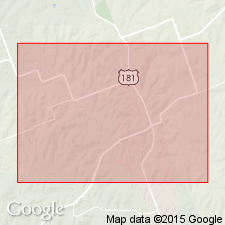
- Areal extent
- AAPG geologic province:
-
- East Texas basin
- Gulf Coast basin
Summary:
Pg. 779-781. McElroy beds. Local. Thickness 500+/- feet. Overlain by Fayette and separated from underlying Cockfield by 100+/- feet of beds [not described] called DIBOLLENSIS zone. Includes in upper part Simms, Holzmark, and Nichols sands. [Age is late Eocene.]
[Origin of name and lithology of beds not stated.]
Source: US geologic names lexicon (USGS Bull. 896, p. 1251).
- Usage in publication:
-
- McElroy zone
- Modifications:
-
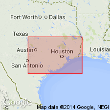
- Areal extent
- AAPG geologic province:
-
- East Texas basin
- Gulf Coast basin
Summary:
Pg. 788. McElroy zone is 500 feet at Pettus [Bee County]. It is bentonitic, grayish brown to brownish, and consists almost entirely of shale. The peculiar McElroy lithology has not been reported in any exposures in Karnes County, eastern Texas. [Age is late Eocene.]
[Origin of name not stated.]
Source: US geologic names lexicon (USGS Bull. 896, p. 1251).
- Usage in publication:
-
- McElroy formation
- Modifications:
-
- Revised
- AAPG geologic province:
-
- Gulf Coast basin
Summary:
McElroy formation, of Jackson group, underlies Whitsett formation, overlies Caddell formation, and is divided into (descending) Manning beds, Wellborn sands, and Wooley's Bluff clays. [Age is late Eocene.]
Source: US geologic names lexicon (USGS Bull. 896, p. 1251).

- Usage in publication:
-
- McElroy member
- Modifications:
-
- Principal reference
- Dominant lithology:
-
- Clay
- AAPG geologic province:
-
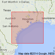
- East Texas basin
- Gulf Coast basin
Summary:
Pg. 530, 680-681, 685-687, 693, 696. McElroy member of Fayette formation was named by Miss Ellisor (ms. read at meeting Soc. Econ. Paleo. and Min., San Antonio, March, 1931) for McElroy, a small town in Sabine County [northeastern Texas]. Previously the basal sandstone beds of this division had been named Wellborn by Kennedy, and the clays above named Manning beds by Dumble. Dumble did not define his division clearly nor designate a type section, and consequently geologists have had difficulty in distinguishing the limits of Manning beds. Cushman and Applin (1926) referred to the middle division of the Fayette as "TEXTULARIA HOCKLEYENSIS zone." Most other geologists have preferred the new name McElroy. The member consists of brownish-gray gypsiferous plastic clays containing fossiliferous, limonitic concretions and layers of thin-bedded fossiliferous sand or sandstone. Thickness averages 200 feet along outcrop. It is limited at top by a more or less persistent sandstone (Alva Ellisor, personal commun., 1932), which passes through town of Groveton, Trinity County, and caps Lipan Hills near Campellton, Atascosa County. [On p. 687 he says top is limited by base of Whitsett member.] It is limited at base by Caddell clays, the dividing line being drawn at base of Wellborn sandstone. Fossils listed. [Age is late Eocene.]
Type locality [no longer exists]: RR cut just north of station of McElroy, a small town north of Brookeland, on Santa Fe RR, in Sabine Co., [northeastern TX].
Source: US geologic names lexicon (USGS Bull. 896, p. 1251).
- Usage in publication:
-
- McElroy formation*
- Modifications:
-
- Principal reference
- Dominant lithology:
-
- Clay
- Tuff
- Sandstone
- AAPG geologic province:
-
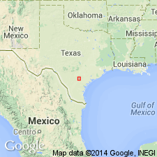
- East Texas basin
- Gulf Coast basin
Summary:
Pg. 2624 (fig. 1), 2626 (table 1), 2628-2631. McElroy formation of Jackson group. Ellisor (AAPG Bull., v. 17, no. 11, 1933) divided the McElroy formation into Manning beds at top, Wellborn sands, and Wooleys Bluff clays. Ellisor considered the McElroy to extend upward to base of Dilworth sand member of Whitsett formation as she grouped these units. Renick (Univ. Texas Bull., no. 3619, 1936) rejected name McElroy and considered the Manning a formation, including in it the Dilworth and Yuma sandstone members. Because name McElroy is in common use in south-central Texas area, it is believed that name McElroy should be retained but the formation expanded to include Dilworth sandstone and overlying Falls City shales of Ellisor (here renamed Conquista clay). McElroy, as redefined here, is practically equivalent to Manning formation of Renick (1936) and consists chiefly of bentonitic clays and tuffs with some interbedded sandstones. Includes (ascending) Manning clay, Dilworth sandstone, and Conquista clay members. Overlies Wellborn sandstone; underlies Whitsett formation. Jackson group. Exposures described. New type locality designated because locality given by Ellisor (1933) could not be located.
Type locality: cuts along Farm Road 705, in southern Augustine Co., about 8 or 10 mi west and southwest of McElroy; road connects Brookeland with State Highway 147 to San Augustine and traverses eastern edge of Angelina National Forest, [northeastern TX].
Source: US geologic names lexicon (USGS Bull. 1200, p. 2297-2298).
- Usage in publication:
-
- McElroy Formation†
- Modifications:
-
- Abandoned
- AAPG geologic province:
-
- East Texas basin
- Gulf Coast basin
Summary:
Upper Eocene †McElroy Formation of south-central Texas is abandoned. Its lowermost member, Manning Clay, raised to formational rank in Jackson Group; its middle and uppermost members, Dilworth Sandstone and Conquista Clay, reassigned to Whitsett Formation.
Source: Changes in stratigraphic nomenclature, 1972 (USGS Bull. 1394-A, p. A26-A27).
For more information, please contact Nancy Stamm, Geologic Names Committee Secretary.
Asterisk (*) indicates published by U.S. Geological Survey authors.
"No current usage" (†) implies that a name has been abandoned or has fallen into disuse. Former usage and, if known, replacement name given in parentheses ( ).
Slash (/) indicates name conflicts with nomenclatural guidelines (CSN, 1933; ACSN, 1961, 1970; NACSN, 1983, 2005, 2021). May be explained within brackets ([ ]).