The National Geologic Map Database is migrating to a new infrastructure. We apologize for any service disruptions during this process.
|
|---|


- Usage in publication:
-
- McDermott formation*
- Modifications:
-
- Named
- Dominant lithology:
-
- Sandstone
- Shale
- Conglomerate
- AAPG geologic province:
-
- San Juan basin
Summary:
Pg. 22-25. McDermott formation. A series of lenticular sandstone, shales, and conglomerates containing much andesitic debris and usually in part of purple color. Described as brown to yellow, soft sandstone; white, coarse-grained, tuffaceous sandstone; purple, yellow, and gray tuffaceous shale; green to drab, coarse-grained conglomerate with matrix of weathered andesitic debris and some quartz, quartzite, chert at "type." Thickness at most places in Colorado 200 to 400 feet; in northern San Juan County, New Mexico, 150 to 200 feet; to the south of San Juan River 30 to 50 feet. Thickness at "typical exposures" 328 feet. Except near Durango, Colorado, the McDermott seems to be conformable with underlying Kirtland shale restricted and boundary to be arbitrary. In Durango region it appears to be unconformable with Kirtland. In Colorado it is in places unconformably overlain by Animas formation (restricted) and in other places the younger Torrejon formation unconformably overlies it. In New Mexico it is unconformably overlain by Ojo Alamo sandstone restricted. The McDermott formation in Colorado was included in lower part of "Animas River beds" of Cross (1896) and Animas formation of Gardner (1909). It is same as Animas formation of Shaler (1907). In New Mexico it was included in upper part of Ojo Alamo beds of Brown (1910), in uppermost part of Kirtland shale of Bauer (1916), and in Ojo Alamo sandstone in part and in Kirtland shale in part of Bauer and Reeside (1921). It is here tentatively assigned to Cretaceous(?), because of somewhat conflicting paleontologic evidence, which, however, on the whole seems to favor Cretaceous age. Fossils (listed): fish, dinosaurs, turtle, plants. Report includes nomenclature history, geologic map, cross sections, measured sections.
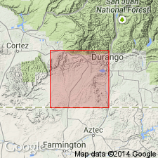
Named from McDermott Arroyo, southwestern La Plata Co., CO. "Typical exposures" [not considered type sections] in secs. 18 and 19, T. 32 N., R. 11 W., La Plata Co., CO., where McDermott is 328 feet thick, conformably overlies Kirtland and unconformably underlies Torrejon.
[GNC remark (ca. 1938, US geologic names lexicon, USGS Bull. 896, p. 1250): This formation now classified as [Late] Cretaceous, since it underlies Ojo Alamo sandstone, which is demonstratably of that age.]
Source: US geologic names lexicon (USGS Bull. 896, p. 1250); supplemental information from GNU records (USGS DDS-6; Denver GNULEX).
- Usage in publication:
-
- McDermott member*
- Modifications:
-
- Revised
- AAPG geologic province:
-
- San Juan basin
Summary:
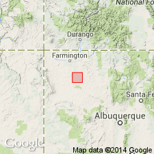
McDermott member of Animas formation. Reeside's (1924) typical section of McDermott in SW/4 NW/4 sec. 19, T. 32 N., R. 11 W., subdivided as follows: lowest 95 feet of pebble-bearing sandstone and sandy shale [shaly sandstone?] is assigned to upper part of Kirtland formation; overlying 127 feet of purplish beds is here termed McDermott member of Animas formation; top 106 feet is included in upper part of Animas. As revised, McDermott is an interbedded reddish-brown to purple breccia, conglomerate, tuffaceous sandstone, and shale. Consists of slightly weathered andesitic detritus, quartz, quartzite and chert. Thickness ranges from 256 (Animas River) to 290 feet. Mapped as a narrow, northeast-trending strip of exposures in La Plata County, Colorado (San Juan basin). Reduction in grain size noted toward southwest part of mapped area. Upper and lower contacts are conformable. Age is Late Cretaceous; probably records an early Laramide volcanism. Report includes geologic map, columnar section.
Source: US geologic names lexicon (USGS Bull. 1200, p. 2295-2296); supplemental information from GNU records (USGS DDS-6; Denver GNULEX).
- Usage in publication:
-
- McDermott Member*
- Modifications:
-
- Areal extent
- AAPG geologic province:
-
- San Juan basin
Summary:
Not recognized in western part of San Juan basin. Thins southward from its type in Colorado and is cut out by an unconformity east of La Plata River northwest of Farmington, New Mexico, near center of T. 30 N., R. 13 W. Beds equivalent to McDermott mapped as lower part of Animas.
Source: GNU records (USGS DDS-6; Denver GNULEX).
For more information, please contact Nancy Stamm, Geologic Names Committee Secretary.
Asterisk (*) indicates published by U.S. Geological Survey authors.
"No current usage" (†) implies that a name has been abandoned or has fallen into disuse. Former usage and, if known, replacement name given in parentheses ( ).
Slash (/) indicates name conflicts with nomenclatural guidelines (CSN, 1933; ACSN, 1961, 1970; NACSN, 1983, 2005, 2021). May be explained within brackets ([ ]).