The National Geologic Map Database is migrating to a new infrastructure. We apologize for any service disruptions during this process.
|
|---|


- Usage in publication:
-
- Mayo formation*
- Modifications:
-
- Named
- Dominant lithology:
-
- Schist
- AAPG geologic province:
-
- Midcontinent region
Summary:
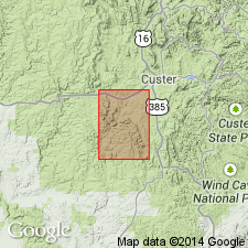
Named for town of Mayo, 1 mi east of Fourmile quad in Horney Peak quad, Custer Co, SD. No type section designated, but a generalized section measured and described along Fourmile Creek in Midcontinent region, where 14,000 ft are exposed between Crow formation (new name) at base and the overlying Paleozoic rocks. Is mostly a light- to dark-gray, medium-grained quartz-mica-feldspar schist. Also has quartz-mica schist, medium- to coarse-grained metagrit, and metaconglomerate, coarse-grained calc-silicate gneiss, and cummingtonite-quartz schist. Assigned to the Precambrian.
Source: GNU records (USGS DDS-6; Denver GNULEX).

- Usage in publication:
-
- Mayo Formation*
- Modifications:
-
- Age modified
- AAPG geologic province:
-
- Midcontinent region
Summary:
Mapped with Early Proterozoic unit Xgw (Pl. 1) west of the Grand Junction fault, Berne and Fourmile quads, Custer Co, SD in the Midcontinent region. Geologic map.
Source: GNU records (USGS DDS-6; Denver GNULEX).
For more information, please contact Nancy Stamm, Geologic Names Committee Secretary.
Asterisk (*) indicates published by U.S. Geological Survey authors.
"No current usage" (†) implies that a name has been abandoned or has fallen into disuse. Former usage and, if known, replacement name given in parentheses ( ).
Slash (/) indicates name conflicts with nomenclatural guidelines (CSN, 1933; ACSN, 1961, 1970; NACSN, 1983, 2005, 2021). May be explained within brackets ([ ]).