The National Geologic Map Database is migrating to a new infrastructure. We apologize for any service disruptions during this process.
|
|---|


- Usage in publication:
-
- Mayflower Hill Formation
- Modifications:
-
- Areal extent
- AAPG geologic province:
-
- New England province
Summary:
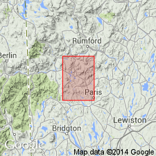
Pg. 25. Mayflower Hill formation. [Rank terms not capitalized, however units are considered formal.] May be equivalent to Patch Mountain formation [new]. Age is Silurian.
Name credited to P.H. Osberg (in prep.) [see Osberg, 1968, Maine Geol. Survey Bull., no. 20].
Source: US geologic names lexicon (USGS Bull. 1350, p. 478).
- Usage in publication:
-
- Mayflower Hill Formation
- Modifications:
-
- Areal extent
- AAPG geologic province:
-
- New England province
Summary:
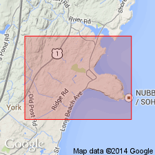
Pg. 73. Mayflower Hill Formation. In vicinity of York Beach, Maine, three distinct groups of rocks recognized. They include Agamenticus Complex, Cape Neddick Complex, and basic dikes. All are intruded into Kittery Formation of Silurian age and correlated with Mayflower Hill Formation, of Waterville area, containing fossils of Llandovery age.
Source: US geologic names lexicon (USGS Bull. 1350, p. 478).
- Usage in publication:
-
- Mayflower Hill Formation*
- Modifications:
-
- Named
- Biostratigraphic dating
- Dominant lithology:
-
- Metasandstone
- Metashale
- AAPG geologic province:
-
- New England province
Summary:
Mayflower Hill Formation. Includes some of the rocks previously mapped as Waterville Slate by Perkins and Smith (1925). Consists of thick beds of light-bluish-gray to gray, coarse-grained metasandstone at base grading to metashale at top; some beds slightly calcareous. Thickness probably exceeds 1,000 feet (300 m), but base of unit is not exposed. Age is Early Silurian, based on presence of late Llandoverian monograptids.
Type locality: Mayflower Hill, just south of Colby College campus, Waterville, Kennebec Co., central ME. Good exposures seen at quarry 1.1 miles (1.8 km) 0 degrees from Colby College, on campus of the college, and 1.3 miles (2.1 km) 97 degrees from Oakland.
Source: Modified from GNU records (USGS DDS-6; Reston GNULEX).
- Usage in publication:
-
- Mayflower Hill Formation†
- Modifications:
-
- Abandoned
- AAPG geologic province:
-
- New England province
Summary:
Lower part of Sangerville Formation replaces rocks called Mayflower Hill in previous reports.
Source: GNU records (USGS DDS-6; Reston GNULEX).
For more information, please contact Nancy Stamm, Geologic Names Committee Secretary.
Asterisk (*) indicates published by U.S. Geological Survey authors.
"No current usage" (†) implies that a name has been abandoned or has fallen into disuse. Former usage and, if known, replacement name given in parentheses ( ).
Slash (/) indicates name conflicts with nomenclatural guidelines (CSN, 1933; ACSN, 1961, 1970; NACSN, 1983, 2005, 2021). May be explained within brackets ([ ]).