The National Geologic Map Database is migrating to a new infrastructure. We apologize for any service disruptions during this process.
|
|---|


- Usage in publication:
-
- Masuk sandstone*
- Modifications:
-
- Original reference
- Dominant lithology:
-
- Sandstone
- AAPG geologic province:
-
- Paradox basin
Summary:
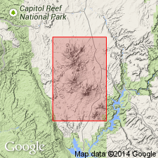
Pg. 4+. Masuk sandstone. Heavy-bedded yellow sandstone, 500 feet thick, overlying Masuk shale in Masuk Plateau. Present in Henry Mountains region, [Wayne and Garfield Counties], central southern Utah. Age is Late Cretaceous.
[GNC remark (ca. 1938, US geologic names lexicon, USGS Bull. 896, p. 1318): Masuk sandstone member of Mesaverde formation. Now treated by USGS as basal member of Mesaverde formation in Henry Mountains region.]
Source: US geologic names lexicon (USGS Bull. 896, p. 1318).
For more information, please contact Nancy Stamm, Geologic Names Committee Secretary.
Asterisk (*) indicates published by U.S. Geological Survey authors.
"No current usage" (†) implies that a name has been abandoned or has fallen into disuse. Former usage and, if known, replacement name given in parentheses ( ).
Slash (/) indicates name conflicts with nomenclatural guidelines (CSN, 1933; ACSN, 1961, 1970; NACSN, 1983, 2005, 2021). May be explained within brackets ([ ]).