The National Geologic Map Database is migrating to a new infrastructure. We apologize for any service disruptions during this process.
|
|---|


- Usage in publication:
-
- Mariposa beds
- Modifications:
-
- Original reference
- Biostratigraphic dating
- Dominant lithology:
-
- Slate
- AAPG geologic province:
-
- Sierra Nevada province
Summary:
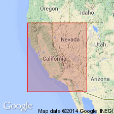
Pg. 18-23. Mariposa beds. An immense thickness of highly metamorphosed auriferous slates occurring along foothills from Mariposa to Nevada [Counties, northern California], and containing AUCELLA [notably Jurassic AUCELLA PIOCHII], BELEMNITES, and other fossils. Thin-bedded strata prevail and silicification and serpentinization are predominant characteristics. The beds are upturned into a nearly vertical position, and are unconformably overlain by Chico beds. Regarded as identical with Knoxville beds [of Coast Ranges].
[Named from occurrence on Mariposa estate, southeast of Bagby, Mariposa Co., northern CA. Extends into Calaveras and neighboring counties.]
Source: US geologic names lexicon (USGS Bull. 896, p. 1301); supplemental information from GNU records (USGS DDS-6; Menlo GNULEX).
- Usage in publication:
-
- Mariposa formation*
- Modifications:
-
- Redescribed
- Dominant lithology:
-
- Slate
- Shale
- Conglomerate
- Schist
- AAPG geologic province:
-
- Sierra Nevada province
Summary:
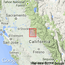
Shown on geologic map of Sonora 30' quad, part of Mariposa, Tuolumne, Merced, and Stanislaus Cos, CA. Occurs in three belts. Rocks of eastern main belt are chiefly clay slates and shales with some coarse grit and conglomerate. In southwestern extension of middle belt are highly metamorphosed mica- and andalustic-schists (shown separately on map). Formation attains maximum development in Mariposa County portion of quad; it is here in eastern belt that first fossils were found from slates northwest of Bear Valley in ravine known as Hell Hollow [this area probably included in site of Mariposa estate].
Source: GNU records (USGS DDS-6; Menlo GNULEX).
- Usage in publication:
-
- Mariposa formation*
- Modifications:
-
- Redescribed
- Dominant lithology:
-
- Slate
- Sandstone
- Conglomerate
- AAPG geologic province:
-
- Sierra Nevada province
Summary:
Shown on geologic map of Mother Lode district, CA. Mariposa formation consists chiefly of cleavable and homogenous clay slates with locally varying amounts of sandstone and conglomerate.
Source: GNU records (USGS DDS-6; Menlo GNULEX).
- Usage in publication:
-
- Mariposa slate*
- Modifications:
-
- Redescribed
- AAPG geologic province:
-
- Sierra Nevada province
Summary:
Associated with amphibolite schist are bands of Mariposa slate in Calaveras Co, CA. Mariposa slate is Jurassic age.
Source: GNU records (USGS DDS-6; Menlo GNULEX).

- Usage in publication:
-
- Mariposa slate
- Modifications:
-
- Overview
- AAPG geologic province:
-
- Sierra Nevada province
Summary:
Mariposa Slate. Beds of sandstone and conglomerate are also included in Mariposa slate, and contemporaneous greenstone is associated and in part interbedded with the formation. In 1910 (Jour. Geol., v. 18, charts opp. P. 217 and 221) J.P. Smith restricted Mariposa to lower part of Mariposa slate of previous reports, or to the slates of the Gold Belt carrying AUCELLA ERRINGTONI and CARDIOCERAS ALTERNANS, and applied the new name Colfax Formation to upper part of the Mariposa, or to the "tuffs and shales of the Gold Belt with PERISPHINCTES COLFAXI." The US Geological Survey uses the original broad definition of the Mariposa, and classifies it as older than Knoxville and of Late Jurassic age.
Named from occurrence on Mariposa estate, southeast of Bagby, Mariposa Co., northern CA. Extends into Calaveras and neighboring counties.
Source: US geologic names lexicon (USGS Bull. 896, p. 1301).
- Usage in publication:
-
- Mariposa formation*
- Modifications:
-
- Redescribed
- Dominant lithology:
-
- Slate
- Graywacke
- Sandstone
- AAPG geologic province:
-
- Sierra Nevada province
Summary:
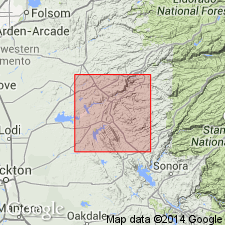
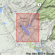
Mapped in Angels Camp and Sonora quads, Calaveras and Tuolumne Cos, CA. Lithology varies; in places slate is minor constituent. In Sonora quad about two-thirds of unit are dark-gray to black slates; rest are metamorphosed fine- to coarse-grained sandstone and grit, graywacke, pebble conglomerate, tuffaceous sandstone and sandy to silty tuff. Believed to be in depositional contact with Logtown Ridge formation along east flank of Peoria Mountain and along flanks of Bear Mountain. Is exposed in partly fault-bounded northwest-trending belt just west of Mother Lode fault system. Belt ranges in thickness up to 12,000 ft. Narrow belt 250 to 1500 ft wide is exposed just west of Bear Mountain. Measured section along Brower Creek and Angels Creek, Calaveras Co. Age is Late Jurassic based on fossils. Discussion of disagreement among paleontologists as to proper stages.
Source: GNU records (USGS DDS-6; Menlo GNULEX).
- Usage in publication:
-
- Mariposa formation*
- Modifications:
-
- Revised
- Biostratigraphic dating
- AAPG geologic province:
-
- Sierra Nevada province
Summary:
(See also L.D. Clark and others, 1963, San Andreas quadrangle, USGS Geol. Quad. Map GQ-222.) Mariposa formation restricted to rocks in central fault block and Melones fault zone that are continuous on surface of type area [Mariposa estate, southeast of Bagby], or are repeated across strike by adequately documented structures. Brower Creek volcanic member of Mariposa formation is here applied to sequences of volcanic rocks, chiefly volcanic breccia, that forms part of Mariposa formation north of Stanislaus River. Mariposa formation exclusive of member consists largely of slate, tuff, graywacke and conglomerate. Overlies Penon Blanco volcanics. Age is Late Jurassic based on fossils identified by R.W. Imlay (written commun., 1959) [USGS Preliminary Report on Referred Fossils MD-59-14, May 20, 1959]. Fossil list included.
[Author does not capitalize rank terms; however, units are considered formal.]
Source: Modified from GNU records (USGS DDS-6; Menlo GNULEX).
- Usage in publication:
-
- Mariposa Formation*
- Modifications:
-
- Areal extent
- AAPG geologic province:
-
- Sierra Nevada province
Summary:
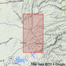
Shown on geologic map of western Sierra foothills between Cosumnes and Mokelumne Rivers, Amador Co, CA. Distinct lithologies of both formation and Brower Creek Volcanic Member shown. Detailed lithologic descriptions in text. Overlies Logtown Ridge Formation. Narrow band (about 250 to 800 m) of distinctive sheared rocks separates Mariposa Formation on west from large granitic pluton and Calaveras Formation of eastern belt to the east. Although unit is considered Late Jurassic (late Oxfordian and early Kimmeridgian Stages), recovery of pelecypod BUCHIA CONCENTRICA above base 1.2 km north-northwest of Plymouth (Imlay, 1961) demonstrates a late Oxfordian and early Kimmeridgian age there.
Source: GNU records (USGS DDS-6; Menlo GNULEX).
For more information, please contact Nancy Stamm, Geologic Names Committee Secretary.
Asterisk (*) indicates published by U.S. Geological Survey authors.
"No current usage" (†) implies that a name has been abandoned or has fallen into disuse. Former usage and, if known, replacement name given in parentheses ( ).
Slash (/) indicates name conflicts with nomenclatural guidelines (CSN, 1933; ACSN, 1961, 1970; NACSN, 1983, 2005, 2021). May be explained within brackets ([ ]).