The National Geologic Map Database is migrating to a new infrastructure. We apologize for any service disruptions during this process.
|
|---|


- Usage in publication:
-
- Maquinita granodiorite
- Modifications:
-
- Named
- Dominant lithology:
-
- Granodiorite
- AAPG geologic province:
-
- Southern Rocky Mountain region
Summary:
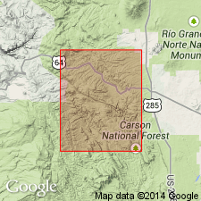
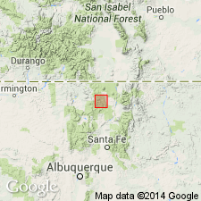
Named for exposures in Maquinita Canyon, secs 3 and 4, T28N, R7E, Rio Arriba Co, NM, Burned Mountain quad, in Southern Rocky Mountain region. Occurs as many small dikes and as parts of small plutons. Plutons lie between American and Cow Creeks on part of lower north slope of Tusas Mountain, along west side upper Tusas Valley southeast and northwest from Maquinita Canyon, and along part of Duran Canyon, Rio Arriba Co. Dikes intrude Moppin intervolcanic series. Isolated patches occur elsewhere in Tusas Valley and at mouth of Canada Biscara. Is a gray to dark gray, homogeneous, well-foliated granodiorite, and is strongly lineate. Thought to be younger than Tres Piedras granite and older than Burned Mountain metarhyolite.
Source: GNU records (USGS DDS-6; Denver GNULEX).
- Usage in publication:
-
- Maquinita Granodiorite*
- Modifications:
-
- Overview
- AAPG geologic province:
-
- Southern Rocky Mountain region
Summary:
Used as a unit in Rio Arriba Co, NM in the Southern Rocky Mountain region, and as defined and described by Barker (1958). Intruded metavolcanic and metasedimentary rocks of the Tusas Mountains assigned to the Moppin Metavolcanics and Burned Mountain Metarhyolite (both revised and adopted) about 1,700 m.y. ago.
Source: GNU records (USGS DDS-6; Denver GNULEX).
For more information, please contact Nancy Stamm, Geologic Names Committee Secretary.
Asterisk (*) indicates published by U.S. Geological Survey authors.
"No current usage" (†) implies that a name has been abandoned or has fallen into disuse. Former usage and, if known, replacement name given in parentheses ( ).
Slash (/) indicates name conflicts with nomenclatural guidelines (CSN, 1933; ACSN, 1961, 1970; NACSN, 1983, 2005, 2021). May be explained within brackets ([ ]).