The National Geologic Map Database is migrating to a new infrastructure. We apologize for any service disruptions during this process.
|
|---|


- Usage in publication:
-
- Maplewood shale
- Modifications:
-
- Named
- Dominant lithology:
-
- Shale
- AAPG geologic province:
-
- Appalachian basin
Summary:
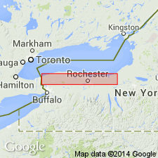
Maplewood shale is new name for basal division of NY Clinton. Maximum exposure in Genesee Gorge at Maplewood Park, Rochester, where 21 ft of fine-grained unctuous bright-green nonfossiliferous shale of uniform texture rests on Thorold sandstone. This is Hall's "Lower green shale" and Hartnagel's "Sodus" exclusive of uppermost 3 ft. This shale probably terminates eastward without reaching Sodus, the true Sodus shale being a higher member. Stratigraphic relations of the Maplewood are with the beds below rather than above. Older than Bear Creek shale and Martville sandstone.
Source: GNU records (USGS DDS-6; Reston GNULEX).

- Usage in publication:
-
- Maplewood†
- Modifications:
-
- Abandoned
- AAPG geologic province:
-
- Appalachian basin
Summary:
The name Maplewood has been abandoned for the basal shale of the Clinton Group and is replaced by the name Neahga, which has been extended throughout the outcrop belt.
Source: GNU records (USGS DDS-6; Reston GNULEX).
- Usage in publication:
-
- Maplewood Shale
- Modifications:
-
- Revised
- Areal extent
- Overview
- AAPG geologic province:
-
- Appalachian basin
Summary:
As currently defined, the basal formation of the Clinton Group in Monroe Co., NY, is the Maplewood Shale, and in western NY and adjacent Ontario, the Neahga Shale. The base of both formations is marked by the distinctive phosphatic Densmore Creek Bed (new). The Maplewood varies in thickness thinning both east and west of the type section. Formation is absent at Webster, 10 km northeast of Glen Edith where it is 5.0 m thick. The Maplewood underlies the Reynales Limestone, the base of which is marked by the Budd Road Bed, and overlies the Kodak Sandstone or Cambria Shale of the Medina Group. The Maplewood has a sparser fossil assemblage than the correlative Neahga Shale to the west and its Llandoverian B-2 to C-1 age assignment is based for the most part on its physical continuity with the Neahga.
Source: GNU records (USGS DDS-6; Reston GNULEX).
For more information, please contact Nancy Stamm, Geologic Names Committee Secretary.
Asterisk (*) indicates published by U.S. Geological Survey authors.
"No current usage" (†) implies that a name has been abandoned or has fallen into disuse. Former usage and, if known, replacement name given in parentheses ( ).
Slash (/) indicates name conflicts with nomenclatural guidelines (CSN, 1933; ACSN, 1961, 1970; NACSN, 1983, 2005, 2021). May be explained within brackets ([ ]).