

- Usage in publication:
-
- Mahogany member*
- Modifications:
-
- Named
- Dominant lithology:
-
- Shale
- Sandstone
- AAPG geologic province:
-
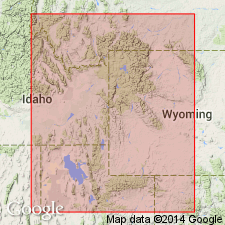
- Uinta uplift
- Wasatch uplift
- Uinta basin
Summary:
Named as the lower member of the Ankareh formation for the Mahogany Hills, north of the Weber River in T1S, R6E, Summit Co, UT on the Uinta uplift. No type locality designated. Can be recognized (cross section) from Fort Douglas, Salt Lake Co on the Wasatch uplift across northern UT east to Whiterocks Canyon in Uintah Co in the Uinta basin. Is a red shale and sandstone sequence that interfingers with the underlying Thaynes formation and that is overlain by the Gartra grit member (reassigned from Stanaker formation) of the Ankareh. Is distinguishable as far east as Thaynes is recognized. East of Whiterocks Canyon the Lower Triassic cannot be divided because Thaynes has pinched out and the undivided Lower Triassic is called Moenkopi formation. Mahogany ranges from 555 ft thick at Whiterocks Canyon to 850 ft thick at Fort Douglas. Assigned to the Early and Late Triassic.
Source: GNU records (USGS DDS-6; Denver GNULEX).
- Usage in publication:
-
- Mahogany Formation*
- Modifications:
-
- Revised
- AAPG geologic province:
-
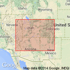
- Uinta uplift
- Uinta basin
Summary:
In the western Uinta Mountains, UT on the Uinta uplift, Mahogany Member of Ankareh Formation, the designation given by Kummel (1954) revised to Mahogany Formation. Base of Ankareh placed at base of Gartra Grit Member. In Wasatch Range, Kummel's use of Mahogany Member of Ankareh is retained. Mahogany composed predominantly of red siltstone, claystone, and some sandstone. Is 450 ft thick in Wasatch Range, 1,400 ft thick in western Uinta Mountains, and 550 ft thick near its eastern limit of recognition in the eastern Uinta Mountains in the Uinta basin. Eastern limit is controlled by presence of underlying Thaynes Formation. Is assigned to the Lower Triassic.
Source: GNU records (USGS DDS-6; Denver GNULEX).
For more information, please contact Nancy Stamm, Geologic Names Committee Secretary.
Asterisk (*) indicates published by U.S. Geological Survey authors.
"No current usage" (†) implies that a name has been abandoned or has fallen into disuse. Former usage and, if known, replacement name given in parentheses ( ).
Slash (/) indicates name conflicts with nomenclatural guidelines (CSN, 1933; ACSN, 1961, 1970; NACSN, 1983, 2005, 2021). May be explained within brackets ([ ]).