The National Geologic Map Database is migrating to a new infrastructure. We apologize for any service disruptions during this process.
|
|---|


- Usage in publication:
-
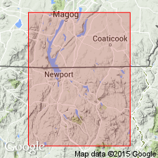
- Magog formation
- Modifications:
-
- Overview
- AAPG geologic province:
-
- New England province
Summary:
Pg. 200. Magog formation of Quebec group. Present in Lake Memphremagog basin. Similar to Norman's kiln shales of New York. Age is Ordovician.
[See also Lexicon of Canadian Geologic Units (http://cgkn1.cgkn.net/weblex/weblex_search_e.pl).]
Source: Publication; Lexicon of Canadian geologic units; GSC cardfile.
- Usage in publication:
-
- Magog conglomerate
- Modifications:
-
- [Principal reference]
- AAPG geologic province:
-
- New England province
Summary:
Pg. 116. Magog conglomerate. Ordovician, Quebec, Canada. Included in Quebec group.
Source: US geologic names lexicon (USGS Bull. 896, p. 1267).
- Usage in publication:
-
- Magog phase
- Modifications:
-
- Revised
- Areal extent
- AAPG geologic province:
-
- New England province
Summary:
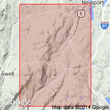
Pg. 107-110. Magog phase of Irasburg conglomerate. Was discovered by Dresser, 1925. Its pebbles are pre-Ordovician and its matrix is Ordovician. It lies at base of my Memphremagog slates. In this report, it conforms to Northfield phase of the Irasburg, which is more than 100 miles farther south. Present in Quebec, Canada, and northeastern Vermont.
Source: US geologic names lexicon (USGS Bull. 896, p. 1267).
For more information, please contact Nancy Stamm, Geologic Names Committee Secretary.
Asterisk (*) indicates published by U.S. Geological Survey authors.
"No current usage" (†) implies that a name has been abandoned or has fallen into disuse. Former usage and, if known, replacement name given in parentheses ( ).
Slash (/) indicates name conflicts with nomenclatural guidelines (CSN, 1933; ACSN, 1961, 1970; NACSN, 1983, 2005, 2021). May be explained within brackets ([ ]).