

- Usage in publication:
-
- Madera diorite*
- Modifications:
-
- First used
- Dominant lithology:
-
- Diorite
- AAPG geologic province:
-
- Southwestern Basin-and-Range region
Summary:
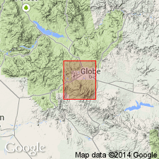
First published use. Name applied to a gray quartz-mica-diorite of granitic texture and habit. Consists of plagioclase feldspar (usually andesine), quartz, and biotite. Becomes a granodiorite in composition at some localities. Named for Mount Madera in the Pinal Mountains, Gila Co, AZ in Southwestern Basin-and-Range region. No type locality designated. Occurs on much of crest of Pinal Mountains, from northwest of Hog Ranch across Lyons Fork of Mineral Creek south to southern border of quad. Is the oldest intrusive rock in quad--older than Schultz granite as it is cut by dikes of the Schultz. Intrudes the Pinal schist. Considered pre-Cambrian age. Geologic map of Globe quad.
Source: GNU records (USGS DDS-6; Denver GNULEX).
- Usage in publication:
-
- Madera Diorite*
- Modifications:
-
- Age modified
- AAPG geologic province:
-
- Southwestern Basin-and-Range region
Summary:
Geologic relations suggest Madera in the Southwestern Basin-and-Range region is older than the 1,400 m.y. Ruin Granite. Thought to be correlative with Willow Spring Granodiorite. Has K-Ar ages of 1,630 +/-60 m.y. and 1,578 +/-8 m.y., and 1,660 m.y. Has Rb-Sr whole rock age of 1,630 m.y. and 1,775 m.y. Age modified from Precambrian to Precambrian Y or X. Cross section.
Source: GNU records (USGS DDS-6; Denver GNULEX).
For more information, please contact Nancy Stamm, Geologic Names Committee Secretary.
Asterisk (*) indicates published by U.S. Geological Survey authors.
"No current usage" (†) implies that a name has been abandoned or has fallen into disuse. Former usage and, if known, replacement name given in parentheses ( ).
Slash (/) indicates name conflicts with nomenclatural guidelines (CSN, 1933; ACSN, 1961, 1970; NACSN, 1983, 2005, 2021). May be explained within brackets ([ ]).