The National Geologic Map Database is migrating to a new infrastructure. We apologize for any service disruptions during this process.
|
|---|


- Usage in publication:
-
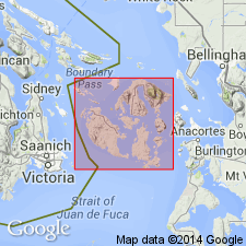
- Lummi Formation
- Modifications:
-
- Named
- Dominant lithology:
-
- Graywacke
- Siltstone
- Shale
- AAPG geologic province:
-
- Puget Sound province
Summary:
Lummi Formation. Consists of gray, brown, and black interbedded graywacke, shale, and siltstone [well-stratified turbidites]. Thickness at type is 1800 m; ranges from 900 to 1800 m. Overlies the Constitution Formation. Age is Cretaceous(?). (B1520)
Source: GNU records (USGS DDS-6; Menlo GNULEX).
For more information, please contact Nancy Stamm, Geologic Names Committee Secretary.
Asterisk (*) indicates published by U.S. Geological Survey authors.
"No current usage" (†) implies that a name has been abandoned or has fallen into disuse. Former usage and, if known, replacement name given in parentheses ( ).
Slash (/) indicates name conflicts with nomenclatural guidelines (CSN, 1933; ACSN, 1961, 1970; NACSN, 1983, 2005, 2021). May be explained within brackets ([ ]).