

- Usage in publication:
-
- Lumbee Group
- Modifications:
-
- Original reference
- Dominant lithology:
-
- Sand
- Clay
- AAPG geologic province:
-
- Atlantic Coast basin
Summary:
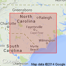
Pg. 201. Lumbee Group. Divided into [ascending] Middendorf, Black Creek, and Peedee Formations. Consists predominantly of sand and clay. Unconformably overlies Cape Fear Formation, Triassic red beds, or Paleozoic crystalline rocks; disconformably underlies Castle Hayne Limestone or Black Mingo Formation. Recognized in South Carolina and North Carolina. Age is Late Cretaceous.
Type section: type sections of component formations [Black Creek, Middendorf, and Peedee, Chesterfield, Darlington, and Florence Cos., eastern SC]. Named from Indian tribe that once occupied outcrop area near Cape Fear.
Source: US geologic names lexicon (USGS Bull. 1520, p. 187).
- Usage in publication:
-
- Lumbee Group
- Modifications:
-
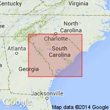
- Areal extent
- AAPG geologic province:
-
- Atlantic Coast basin
Summary:
Lumbee Group, according to this report, is still in use. It is subdivided into Middendorf, Black Creek, and Peedee Formations as originally defined. Group unconformably underlies Paleocene and Eocene Black Mingo Group and unconformably overlies pre-Late Cretaceous Piedmont rocks.
Source: GNU records (USGS DDS-6; Reston GNULEX).
For more information, please contact Nancy Stamm, Geologic Names Committee Secretary.
Asterisk (*) indicates published by U.S. Geological Survey authors.
"No current usage" (†) implies that a name has been abandoned or has fallen into disuse. Former usage and, if known, replacement name given in parentheses ( ).
Slash (/) indicates name conflicts with nomenclatural guidelines (CSN, 1933; ACSN, 1961, 1970; NACSN, 1983, 2005, 2021). May be explained within brackets ([ ]).