

- Usage in publication:
-
- Luman tongue*
- Modifications:
-
- Original reference
- Dominant lithology:
-
- Oil-shale
- Sandstone
- Siltstone
- Shale
- AAPG geologic province:
-
- Green River basin
Summary:
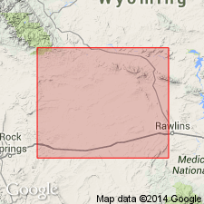
Pg. 100, 101 (chart). Luman tongue of Green River formation. Sequence of oil shale, fossiliferous calcareous sandstone, varved siltstone, and clay shale. Contains several tongues of low-grade oil shale. In north-central part of Great Divide basin base of lowest oil shale tongue contains so-called pastel limestone marker bed. Thickness 180 feet at Luman Butte and thickens eastward to 270 feet in vicinity of Lost Creek Butte; about 200 feet at Tipton Station and about 390 feet at Frewen Station. Overlies Red Desert tongue (new) and underlies Niland tongue (new) of Wasatch formation. Intertongues with Battle Spring formation (new) to north. Age is early Eocene.
Named from exposures on south slope of Luman Butte, in sec. 34, T. 24 N., R. 97 W., Sweetwater Co., southwestern WY.
Source: US geologic names lexicon (USGS Bull. 1200, p. 2276).
- Usage in publication:
-
- Luman Member, Tongue
- Modifications:
-
- Areal extent
- AAPG geologic province:
-
- Green River basin
Summary:
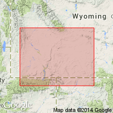
Areal limits map (fig 2) shows Luman to occur in area of southern Green River Basin, Rock Springs uplift, Great Divide Basin, and Washakie Basin, all within Greater Green River basin, WY. Luman is one of five members of Green River Formation which consists of (ascending): Ramsey Ranch Member (new), Luman, Tipton Shale Member, Wilkins Peak Member, and Laney Shale Member. Chart showing previous nomenclature; restored section. Eocene age.
Source: GNU records (USGS DDS-6; Denver GNULEX).
- Usage in publication:
-
- Luman Tongue*
- Modifications:
-
- Areal extent
- Overview
- AAPG geologic province:
-
- Green River basin
Summary:
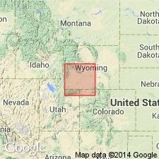
Isopach map (fig 17) shows areal extent within Greater Green River basin, WY and CO. Lake in which Luman (Green River Formation) was deposited was 175 mi long by 60 mi wide. Luman deposited along north flank of Uinta Mountains, across Rock Springs uplift, and in parts of Great Divide, Washakie, and Sand Wash basins. Maximum thickness is 455 ft in southwest part of Washakie basin. Stratigraphic chart; cross sections. Eocene age.
Source: GNU records (USGS DDS-6; Denver GNULEX).
- Usage in publication:
-
- Luman Tongue*
- Modifications:
-
- Overview
- AAPG geologic province:
-
- Green River basin
Summary:
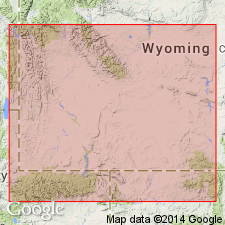
Paleogeographic map (fig. 46) of this lower tongue of Green River Formation showing depositional environments in Greater Green River basin. Lake Gosiute reached a maximum size of about 6650 sq mi during Luman time. Shoreline sands were deposited around margins of lake. Lake reached a depth of 400 ft about 25 mi northeast of common boundary of WY, UT, and CO. Surrounding the lake were narrow bands of gray and green flood-plain deposits; arkosic deltaic deposits of the Battle Spring Formation mixed with Luman along northeastern shores of lake. Lacustrine deposits formed mostly oil shale. Overlies Ramsey Ranch Member of Wasatch Formation; underlies Niland Tongue of Wasatch. Generalized stratigraphic correlation chart (fig. 41). Geologic map (fig. 1) of Vermilion Creek area, northwest CO. Eocene age.
Source: GNU records (USGS DDS-6; Denver GNULEX).
For more information, please contact Nancy Stamm, Geologic Names Committee Secretary.
Asterisk (*) indicates published by U.S. Geological Survey authors.
"No current usage" (†) implies that a name has been abandoned or has fallen into disuse. Former usage and, if known, replacement name given in parentheses ( ).
Slash (/) indicates name conflicts with nomenclatural guidelines (CSN, 1933; ACSN, 1961, 1970; NACSN, 1983, 2005, 2021). May be explained within brackets ([ ]).