The National Geologic Map Database is migrating to a new infrastructure. We apologize for any service disruptions during this process.
|
|---|


- Usage in publication:
-
- Ludlow lignitic member*
- Modifications:
-
- Original reference
- Dominant lithology:
-
- Sandstone
- Shale
- Lignite
- AAPG geologic province:
-
- Williston basin
Summary:
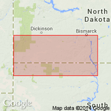
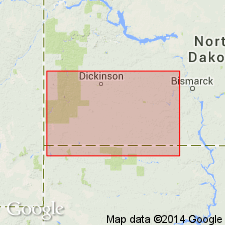
Pg. 523-547. [See 1915 entry under Cannonball marine member. The following additional details regarding the Ludlow member are also given in report cited above.] Ludlow lignitic member of Lance formation occupies large area in Harding County, South Dakota, and has been mapped northward into Bowman and Billings Counties, North Dakota, and eastward in Perkins County, South Dakota, where it merges with Cannonball marine member. In vicinity of Ludlow, South Dakota, its type locality, it consists of 350 feet of loosely consolidated buff and cream-colored calcareous sandstone and shale with interbedded lignite. It contains most of lignite of South Dakota, and the presence of this lignite is one of chief criteria for considering it a distinct member of Lance formation. In South Dakota its lithologic character is very like Fort Union formation and its fossil flora so far as determined is identical with that of Fort Union; its flora is like that of lower part of Lance, but its lithology is quite different. In North Dakota its flora has same afflnities as in South Dakota, but its lithology resembles lower part of Lance except for presence of numerous lignite beds. It is this variation in color and lithology that renders its separation from overlying Fort Union so difficult. All of the TRICERATOPS collected in Little Missouri country came from below the T Cross lignite bed [in lower part of the Ludlow] and the oysters from above it. Calvert, however, states that in Montana ceratopsian bones were found just above the lowest persistent lignite bed, but there is certainly nothing in character of overlying strata to suggest that similar bones do not occur therein up through a stratigraphic diatance of perhaps 500 feet (USGS Bull. 471, p. 197, 1912). The T Cross lignite bed was mapped to Montana State line, and it is undoubtedly the same lignite as the "persistent lignite" referred to above.
[See also D.E. Winchester and others, 1916 (USGS Bull. 627, p. 15-26), and T.W. Stanton, 1920 (USGS Prof. Paper 128-A).]
[GNC remark (ca. 1936, US geologic names lexicon, USGS Bull. 896, p. 1234): The USGS now classifies Cannonball marine member of Lance formation and the demonstrably equivalent part of the Ludlow member as Upper Cretaceous.]
Source: US geologic names lexicon (USGS Bull. 896, p. 1234).
- Usage in publication:
-
- Ludlow Formation
- Modifications:
-
- Revised
- AAPG geologic province:
-
- Williston basin
Summary:
Ludlow Formation of Fort Union Group. Stratigraphically restricted to lower part of formation of previous workers. As restricted, approximately = unnamed lower unit of Moore, 1976 (North Dakota Geol. Survey Rpt. Inv., no. 56, see fig. 2). Is basal formation of Fort Union Group. [Consists of lignite, clay, silt, and sand. Thickness 50+ feet (15+ m).] Top of formation placed at top of T Cross bed (informal). Underlies Slope Formation (new, approximately = Moore's unnamed upper unit of the Ludlow) of Fort Union Group. Overlies Cretaceous Hell Creek Formation. Age is Paleocene.
Source: Publication.
- Usage in publication:
-
- Ludlow Member*
- Modifications:
-
- Areal extent
- AAPG geologic province:
-
- Williston basin
Summary:
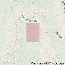
Is lowest member of the Fort Union Formation in eastern Custer Co, MT in Williston basin. Is mapped throughout most of quadrangle except for small area in northwest corner where the Ludlow is laterally equivalent to Lebo Shale Member and Tullock Member of the Fort Union Formation which are separately mapped. Gradational contact with underlying Upper Cretaceous Hell Creek Formation. Is assigned to the Paleocene Epoch.
Source: GNU records (USGS DDS-6; Denver GNULEX).
- Usage in publication:
-
- Ludlow Member*
- Modifications:
-
- Areal extent
- AAPG geologic province:
-
- Williston basin
Summary:
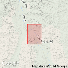
Is lowest member of the Fort Union Formation in eastern Custer Co, MT in the Williston basin. Is mapped only in southern part of quadrangle except for small area west of divide that separates Powder River from Mizpah Creek. Beyond arbitrary cutoff, is laterally equivalent to Lebo and Tullock Members of the Fort Union Formation which are separately mapped. Gradational contact with underlying Upper Cretaceous Hell Creek Formation. Is assigned to the Paleocene Epoch.
Source: GNU records (USGS DDS-6; Denver GNULEX).
For more information, please contact Nancy Stamm, Geologic Names Committee Secretary.
Asterisk (*) indicates published by U.S. Geological Survey authors.
"No current usage" (†) implies that a name has been abandoned or has fallen into disuse. Former usage and, if known, replacement name given in parentheses ( ).
Slash (/) indicates name conflicts with nomenclatural guidelines (CSN, 1933; ACSN, 1961, 1970; NACSN, 1983, 2005, 2021). May be explained within brackets ([ ]).