

- Usage in publication:
-
- Love Ranch formation
- Modifications:
-
- Named
- Dominant lithology:
-
- Conglomerate
- Sandstone
- Siltstone
- AAPG geologic province:
-
- Orogrande basin
Summary:
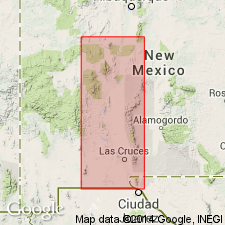
Named for exposures northwest of Love Ranch, Dona Ana Co, NM in the Orogrande basin. Section on ranch measured at center of south line of SW1/4 sec 19, T20S, R4E north-northwest of ranch headquarters where the formation unconformably overlies Eagle Ford formation, is 408 ft thick, consists of boulder conglomerate interbedded with reddish calcareous siltstone and reddish greenish limy arkosic coarse-grained poorly sorted sandstone, and one 3-ft thick brown mottled gray andesite tuff. The conglomerate forms ledges and cliffs. The boulders are limestone, shale, sandstone in a gray calcareous sandstone or arenaceous calcarenite matrix. Conglomerate eroded from rocks of the Eagle Ford to Hueco formation age. Grains in the matrix are angular to subround. Is cross-bedded to horizontal bedded. Coarse material derived from nearby source. Exposed in foothills of San Andres Mountains, along west side of Organ Mountains between Fillmore and Baylor Canyons, and Target Canyon, south end of Organ Mountains. May be as much as 2,100 ft thick at type; less than 100 ft thick in Organ Mountains. Only plant fragments found. Rests unconformably on beds as old as Pennsylvanian. Correlations with Eocene rocks described. Tertiary age.
Source: GNU records (USGS DDS-6; Denver GNULEX).
- Usage in publication:
-
- Love Ranch Formation
- Modifications:
-
- Overview
- AAPG geologic province:
-
- Orogrande basin
Summary:
Shown on a cross section as a 1,000 ft thick unit of early Tertiary and Eocene age, as overlying and intertonguing with the Lobo Formation, and as beneath Rubio Peak Formation. Crops out on flanks of Mt. Riley and Mt. Cox plugs on southeast flank of West Potrillo Mountains, Dona Ana Co, NM in the Orogrande basin. Lowest exposures are cobble-boulder conglomerate made up of detritus from Lower Cretaceous and Permian rocks. [Upper part?] is red mudstone and siltstone, tan to olive sandstone and some conglomerate that has andesite and rhyolite clasts.
Source: GNU records (USGS DDS-6; Denver GNULEX).
For more information, please contact Nancy Stamm, Geologic Names Committee Secretary.
Asterisk (*) indicates published by U.S. Geological Survey authors.
"No current usage" (†) implies that a name has been abandoned or has fallen into disuse. Former usage and, if known, replacement name given in parentheses ( ).
Slash (/) indicates name conflicts with nomenclatural guidelines (CSN, 1933; ACSN, 1961, 1970; NACSN, 1983, 2005, 2021). May be explained within brackets ([ ]).