The National Geologic Map Database is migrating to a new infrastructure. We apologize for any service disruptions during this process.
|
|---|


- Usage in publication:
-
- Louisiana limestone
- Modifications:
-
- Named
- Dominant lithology:
-
- Limestone
- AAPG geologic province:
-
- Lincoln anticline
Summary:
Named as lower of three formations of Kinderhook group (revised) for Louisiana, Pike Co, MO, Lincoln anticline, where typical exposures occur. Formerly called Lithographic limestone of Chemung group by Swallow (1855, Annual Report of Geological Survey of MO). Outcrops appear as high, mural escarpments, giving appearance of artificial masonry. Texture is very similar to that of stones used in lithography, however, this texture does not extend throughout its entire range. Consists usually of thin beds from 4-6 in thick; lower layers are more or less arenaceous and contain numerous fossils [not described]. Maximum thickness is more than 60 ft at Louisiana. Consists of bed 6 of measured Louisiana exposures. Overlies an unnamed 6 ft-thick dark clayey shale which in turn overlies a magnesian limerock of probable Silurian age. Underlies Hannibal shales (new) of Kinderhook. Mississippian age.
Source: GNU records (USGS DDS-6; Denver GNULEX).
- Usage in publication:
-
- Louisiana Limestone
- Modifications:
-
- Overview
- Areal extent
- AAPG geologic province:
-
- Illinois basin
Summary:
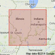
The Louisiana is a light-gray to tan micritic limestone containing thin beds of shale and dolomite. Generally a fine-grained micritic limestone in the subsurface, but in many places, argillaceous and extensively burrowed. Crops out in the Illinois and Mississippi River valleys in northeastern MO and westernmost IL. In subsurface, present as a narrow band extending from central IA into west-central IL Maximum thickness in IL is about 30 ft near the Mississippi River; less than 10 ft toward east. Conformably overlies and grades laterally into the Saverton Shale or lies directly on Grassy Creek Shale where the Saverton is absent. In much of western IL, is unconformably overlain by the Horton Creek Formation. Near the Mississippi, the Louisiana is overlain by the Hannibal Shale. Contains a conodont fauna of latest Devonian age. Has been correlated with the upper part of the Clegg Creek Member of the New Albany Shale in IN.
Source: GNU records (USGS DDS-6; Reston GNULEX).
For more information, please contact Nancy Stamm, Geologic Names Committee Secretary.
Asterisk (*) indicates published by U.S. Geological Survey authors.
"No current usage" (†) implies that a name has been abandoned or has fallen into disuse. Former usage and, if known, replacement name given in parentheses ( ).
Slash (/) indicates name conflicts with nomenclatural guidelines (CSN, 1933; ACSN, 1961, 1970; NACSN, 1983, 2005, 2021). May be explained within brackets ([ ]).