The National Geologic Map Database is migrating to a new infrastructure. We apologize for any service disruptions during this process.
|
|---|


- Usage in publication:
-
- Lotta Creek Tuff Member
- Modifications:
-
- Original reference
- Dominant lithology:
-
- Tuff
- Shale
- AAPG geologic province:
-
- San Joaquin basin
Summary:
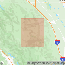
Lotta Creek Tuff Member of Franciscan Formation. White crystalithic tuff and interbedded dark-green siliceous shale at headwaters of Lotta Creek. About 900 feet of strata exposed between lower fault contact with Del Puerto Keratophyre Member and upper conformable contact with Knoxville(?) Formation. Though contact is faulted at exposures, regional structural relationships indicate that Lotta Creek rocks directly overlie those of the Del Puerto. Age is Late Jurassic.
Well exposed along headwaters of Lotta Creek in sec. 21, T. 6 S., R. 6 E., Stanislaus Co., central CA.
Source: US geologic names lexicon (USGS Bull. 1350, p. 441).
For more information, please contact Nancy Stamm, Geologic Names Committee Secretary.
Asterisk (*) indicates published by U.S. Geological Survey authors.
"No current usage" (†) implies that a name has been abandoned or has fallen into disuse. Former usage and, if known, replacement name given in parentheses ( ).
Slash (/) indicates name conflicts with nomenclatural guidelines (CSN, 1933; ACSN, 1961, 1970; NACSN, 1983, 2005, 2021). May be explained within brackets ([ ]).