

- Usage in publication:
-
- Lost River Member
- Modifications:
-
- Named
- Dominant lithology:
-
- Dolomite
- Sandstone
- AAPG geologic province:
-
- Idaho Mountains province
Summary:
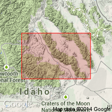
Named as basal member of Fish Haven Dolomite for exposures in Lost River Range, Custer Co, ID in Idaho Mountains province. No type locality designated. Section measured on west side of Bear Canyon above Little Lost River valley in SW1/4 sec 6, T11N, R26E where member is 287 ft thick, and lies between Kinnikinic Quartzite (below) and upper part of Fish Haven (above). Lower part consists of light-brown, dolomite-cemented, fine-grained quartz arenite. Upper part consists of medium-gray, very fine crystalline dolomite with abundant wavy white dolomite seams, several zones of chert nodules, and abundant crinoid columnals, corals, and brachiopods. Brachiopods (list) are very abundant. Has more Late than Middle Ordovician affinities. Is part of the miogeosynclinal sequence that is replaced westward by Saturday Mountain Formation in Bayhorse region and by Phi Kappa Formation in the eugeosyncline. Correlation chart. Block diagram. Cross section.
Source: GNU records (USGS DDS-6; Denver GNULEX).
- Usage in publication:
-
- Lost River Member*
- Modifications:
-
- Revised
- AAPG geologic province:
-
- Idaho Mountains province
Summary:
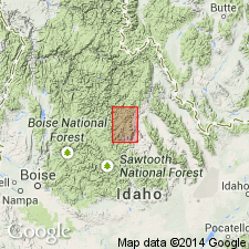
Defined by Churkin (1962) as a member of Fish Haven Dolomite. Revised as the basal member of the Saturday Mountain Formation in Lemhi Range, Lemhi Co, central ID in the Idaho Mountains province. Ranges from 0 to 17 m thick. Consists of pale brown to dark gray, medium-grained, partly argillaceous or silty, dolomitic sandstone that has well-rounded and well-sorted quartz sand, gray, fine- to medium-grained quartzite, gray shale and mudstone. Overlies Kinnikinic Quartzite. Underlies main part of Saturday Mountain. Of Middle Ordovician age.
Source: GNU records (USGS DDS-6; Denver GNULEX).
For more information, please contact Nancy Stamm, Geologic Names Committee Secretary.
Asterisk (*) indicates published by U.S. Geological Survey authors.
"No current usage" (†) implies that a name has been abandoned or has fallen into disuse. Former usage and, if known, replacement name given in parentheses ( ).
Slash (/) indicates name conflicts with nomenclatural guidelines (CSN, 1933; ACSN, 1961, 1970; NACSN, 1983, 2005, 2021). May be explained within brackets ([ ]).