The National Geologic Map Database is migrating to a new infrastructure. We apologize for any service disruptions during this process.
|
|---|


- Usage in publication:
-
- Lost City limestone
- Modifications:
-
- Original reference
- Dominant lithology:
-
- Limestone
- AAPG geologic province:
-
- Chautauqua platform
Summary:
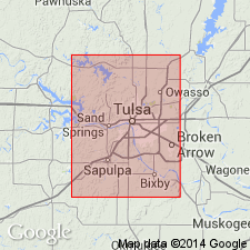
Pg. 179. Lost City limestone. A ledge of limestone which forms a prominent exposure on high hills south of Arkansas River a few miles southwest of Tulsa is known as Lost City limestone. It is quarried at town of Lost City. Age is Pennsylvanian.
Named from exposures near Lost City, near Sand Springs, Tulsa Co., northeastern OK.
Source: US geologic names lexicon (USGS Bull. 896, p. 1220).
- Usage in publication:
-
- Lost City limestone†
- Modifications:
-
- Not used
- AAPG geologic province:
-
- Chautauqua platform
Summary:
Pg. 73. On hills south of Arkansas River west of Tulsa [Oklahoma], the Hogshooter limestone, which has long been known as "Lost City" limestone, thickens to 20 feet.
Source: US geologic names lexicon (USGS Bull. 896, p. 1220).
- Usage in publication:
-
- Lost City member
- Modifications:
-
- Revised
- AAPG geologic province:
-
- Chautauqua platform
Summary:
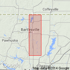
Pg. 44. Lost City member of Hogshooter formation. Rank reduced to member status in Hogshooter formation. In Washington County [Oklahoma], a 5-foot soft gray platy limestone bed is referred to Lost City member. Underlies Winterset member; overlies Stark or Canville; regarded as time equivalent of both Canville limestone and Stark shale members. Age is Late Pennsylvanian (Missourian).
Source: US geologic names lexicon (USGS Bull. 1200, p. 2237).
- Usage in publication:
-
- Lost City member
- Modifications:
-
- Overview
- AAPG geologic province:
-
- Chautauqua platform
Summary:
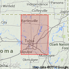
Pg. 61-62. [Lost City member of Hogshooter formation.] Described in Tulsa County [Oklahoma], where thickness ranges from 3 feet at northernmost exposure to 50 feet south of Arkansas River. Age is Late Pennsylvanian (Missourian).
Source: US geologic names lexicon (USGS Bull. 1200, p. 2237).
For more information, please contact Nancy Stamm, Geologic Names Committee Secretary.
Asterisk (*) indicates published by U.S. Geological Survey authors.
"No current usage" (†) implies that a name has been abandoned or has fallen into disuse. Former usage and, if known, replacement name given in parentheses ( ).
Slash (/) indicates name conflicts with nomenclatural guidelines (CSN, 1933; ACSN, 1961, 1970; NACSN, 1983, 2005, 2021). May be explained within brackets ([ ]).