The National Geologic Map Database is migrating to a new infrastructure. We apologize for any service disruptions during this process.
|
|---|


- Usage in publication:
-
- Loray formation
- Modifications:
-
- Original reference
- Dominant lithology:
-
- Siltstone
- Limestone
- Dolomite
- Gypsum
- Anhydrite
- AAPG geologic province:
-
- Great Basin province
Summary:
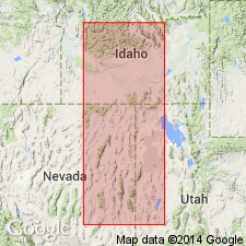
Pg. 93 (chart 1), 105, (pl. 6, fig. 2), 106-107. (Road logs dated Sept. 8-10.) Loray formation. Formal proposal of name. Sequence of yellow-tan, gypsiferous silts and thin bioclastic limestones. At type locality, conformable with underlying Pequop formation (new) and overlain by Kaibab formation. Thickness 2,475 feet in central Butte Mountains, [sec. 27 and 28, T. 21 N., R. 59 E.], White Pine County, eastern Nevada; here rests on Upper Moorman Ranch member of Pequop and underlies Plympton formation. Identified at [Ferguson Mountain], Gold Hill, Cherry Creek Mountains, and Pequop Mountains. Probably equivalent to upper 300 to 400 feet of Hose and Repenning's (1959) measured Arcturus formation in Confusion Range, Utah. Age is considered Permian (Guadalupian).
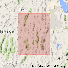
[Type locality]: exposures at head of Loray Wash in Southern Pacific RR cut on southwest side of Montello Valley, in SW/4 NE/4 sec. 28, T. 38 N., R. 68 E., Elko Co., eastern NV. [Extends into White Pine County, Nevada, and western Box Elder, Tooele, Juab, and Millard Counties, Utah.]
[Lower Moorman Ranch member and Upper Moorman Ranch member not adopted by the USGS as formal members; nomenclature guidelines state the use of identical geographic names to several minor stratigraphic units in one vertical sequence is considered informal nomenclature (CSN, 1933; ACSN, 1961, 1970; NACSN, 1983, 2005, 2021).]
Source: US geologic names lexicon (USGS Bull. 1200, p. 2231).
- Usage in publication:
-
- Loray Formation
- Modifications:
-
- Revised
- AAPG geologic province:
-
- Great Basin province
Summary:
Pg. 574 (fig. 2), 576-577 (fig. 3), 604 (fig. 8), 614+. Loray Formation of Arcturus Group. Red, brown, gray, white, thin-bedded to massive shale, siltstone, mudstone, limestone, dolomite, gypsum, and collapse-breccia. Thickness 125 to 500 feet. Top formation of Arcturus Group (rank raised). Underlies Kaibab Limestone of Park City Group; overlies Pequop Formation of Arcturus Group. Age is considered late Leonardian to early Guadalupian (placement of Leonardian-Guadalupian boundary uncertain); ammonite zones PROPINACOCERAS sp., NEOCRIMITES sp., PERITROCHIA sp.
Notable exposures in Rib Hill district, Butte Mountains, Carlin Canyon, Pequop Mountains, Ferguson Mountain, eastern NV, and Gold Hill district and Confusion Range, western UT.
Source: Publication.
For more information, please contact Nancy Stamm, Geologic Names Committee Secretary.
Asterisk (*) indicates published by U.S. Geological Survey authors.
"No current usage" (†) implies that a name has been abandoned or has fallen into disuse. Former usage and, if known, replacement name given in parentheses ( ).
Slash (/) indicates name conflicts with nomenclatural guidelines (CSN, 1933; ACSN, 1961, 1970; NACSN, 1983, 2005, 2021). May be explained within brackets ([ ]).