

- Usage in publication:
-
- Lorane shale member
- Modifications:
-
- Original reference
- Dominant lithology:
-
- Shale
- Mudstone
- AAPG geologic province:
-
- Western Columbia basin
Summary:
Lorane shale member of Spencer formation. Name applied to basal shale and mudstone of Spencer formation (redefined). Thickness about 600 feet; figure varies due to thinning of member toward south and to local irregularities on surface of Tyee formation on which it was deposited. Intercalated sandstones, siltstones, shales, and mudstones at top of member gradually pass into typical sandstones of the formation.
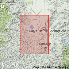
Type locality: north of Lorane, in valley of North Fork of Siuslaw River, in S/2 sec. 36, T. 19 S., R. 5 W., and sec. 1, T. 20 S., R. 5 W., [Cottage Grove 15-min quadrangle, 1947 ed.], Lane Co., western OR.
Source: US geologic names lexicon (USGS Bull. 1200, p. 2230-2231).
- Usage in publication:
-
- Lorane shale member
- Modifications:
-
- Areal extent
- AAPG geologic province:
-
- Western Columbia basin
Summary:
Discussion of west-central border area of Willamette Valley. Uppermost exposed part of Tyee formation consists of thin-bedded siltstone and mudstone. Beds in an equivalent stratigraphic position in Eugene area were mapped as Lorane shale member of Spencer by Vokes and others (1951) who estimated thickness of sequence to be about 600 feet. Mapping in Corvallis-Monroe area indicates that Lorane shale member is more closely related to Tyee formation than to Spencer formation. [Age is middle Eocene.]
Source: US geologic names lexicon (USGS Bull. 1200, p. 2230-2231).
- Usage in publication:
-
- Lorane Shale Member
- Modifications:
-
- Overview
Summary:
Pg. 26. Although Vokes and others (1951) included the Lorane Siltstone Member in the lower Spencer Formation, it is now considered to be part of the Tyee Formation. (See also entries under Elkton Siltstone Member and Tyee Formation).
Source: Publication.
For more information, please contact Nancy Stamm, Geologic Names Committee Secretary.
Asterisk (*) indicates published by U.S. Geological Survey authors.
"No current usage" (†) implies that a name has been abandoned or has fallen into disuse. Former usage and, if known, replacement name given in parentheses ( ).
Slash (/) indicates name conflicts with nomenclatural guidelines (CSN, 1933; ACSN, 1961, 1970; NACSN, 1983, 2005, 2021). May be explained within brackets ([ ]).